On this page
- 01Fifteen winter treks, Ladakh to Wayanad
- 02The fifteen treks at a glance
- 03Himalayan snow treks
- 04High-altitude winter adventures
- 05Winter hiking beyond the Himalayas
- 06Best winter treks for beginners
- 07Best winter treks for experienced trekkers
- 08Winter trekking essentials and safety
- 09Winter packing checklist
- 10How to plan and navigate your winter trek
- 11Find your next winter trail
In summer, the Himalayan trails are busy, green and loud with water. Come back in January and the same trail is a different place. The streams have gone quiet under ice. The forest is white to the top of every branch. The sky, washed clean by the cold, is the deepest blue you'll see all year, and on the ridge above camp the big peaks stand out so sharply you feel you could reach across the valley and touch them.
Winter is the season most people leave the mountains alone, and that's a large part of its appeal. The meadows are empty, the light is long and low, and the walking is quieter than at any other time of year. It is also, by a long way, the best season for the trails that summer makes miserable. When the Himalaya is under snow, the Western Ghats and the hills of the south are at their best: the monsoon mud has dried, the grass is gold, and the mornings are cool enough to climb in comfort.
This guide covers fifteen of India's best winter treks, from snow summits in Garhwal to the frozen Zanskar river and the grassy peaks of Coorg and Wayanad. Fourteen of them are real TrailX routes you can open, download as GPX and fly through in 3D before you go. For each one, we give the distance, the climbing and the high point from the route's GPS track, the best months, what the snow does, and what you need to know about permits and guides.
Fifteen winter treks, Ladakh to Wayanad
The treks fall into three groups on the map.
Most of the Himalayan snow treks sit in Uttarakhand's Garhwal, between the Tons valley in the west and the Nanda Devi massif in the east, with one, Sandakphu, far to the east on the Nepal border in Darjeeling. These are the classic winter treks of India: multi-day walks to summits, lakes and meadows between about 2,400 and 3,800 m, where snow is part of the experience rather than an obstacle.
North of them, the high-altitude winter adventures in Ladakh and Spiti are a different proposition. Night temperatures fall to −20 °C and below, access is limited, and the Chadar trek on the frozen Zanskar runs only when the authorities judge the ice safe. These are specialist trips, not winter hikes.
And far to the south, the Western Ghats trails in Maharashtra, Karnataka and Kerala are day hikes and overnight walks below 2,000 m. There's no snow here. Winter is simply their best season: clear, cool and dry.
The fifteen treks at a glance
| Trek | Region | TrailX route | Distance | Climbing | High point | Best months | Our grade |
|---|---|---|---|---|---|---|---|
| Kedarkantha | Uttarkashi, Uttarakhand | Kedarkantha Trek from Sankri | 19.9 km loop | 1,860 m | 3,796 m | Late Dec–Mar | Moderate |
| Brahmatal | Chamoli, Uttarakhand | Brahmatal Trek from Lohajung | 21.1 km loop | 1,490 m | 3,368 m | Dec–Mar | Moderate |
| Dayara Bugyal | Uttarkashi, Uttarakhand | Dayara Bugyal Trek from Raithal | 22.9 km return | 1,400 m | 3,596 m | Dec–Mar | Easy–moderate |
| Kuari Pass | Chamoli, Uttarakhand | Kuari pass trail | 18.3 km one way | 1,940 m | 3,608 m | Dec–Mar | Moderate |
| Nag Tibba | Tehri Garhwal, Uttarakhand | Nag Tibba Trek from Pantwari | 16.9 km return | 1,550 m | 2,988 m | Dec–Feb | Easy–moderate |
| Deoria Tal | Rudraprayag, Uttarakhand | Deoria Tal | 1.8 km one way | 330 m | 2,385 m | Dec–Mar | Easy |
| Har Ki Dun | Uttarkashi, Uttarakhand | Har Ki Dun Trek from Taluka | 47.4 km return | 1,680 m | 3,484 m | Dec–Mar | Moderate |
| Sandakphu–Phalut | Darjeeling, West Bengal | Sandakphu to Phalut Ridge Trek | 16.9 km one way | 560 m | 3,587 m | Oct–Mar | Moderate |
| Chadar | Zanskar, Ladakh | No route: the ice changes daily | 2–3 days on the ice | – | about 3,400 m | Mid-Jan–Feb | Difficult, specialist |
| Spiti in winter | Lahaul and Spiti, Himachal Pradesh | Dhankar Lake | 2.5 km one way | 290 m | 4,129 m | Jan–Mar | Specialist (cold) |
| Kalsubai | Ahilyanagar, Maharashtra | Kalsubai Peak Trek from Bari | 8.2 km return | 750 m | 1,542 m | Nov–Feb | Moderate |
| Rajmachi | Pune, Maharashtra | Rajmachi Trek from Lonavala | 13.7 km one way | 350 m | 775 m | Nov–Feb | Easy |
| Kudremukh | Chikkamagaluru, Karnataka | Kudremukh Peak Trek | 16.6 km return | 810 m | 1,836 m | Oct–Jan | Moderate |
| Tadiandamol | Kodagu, Karnataka | Tadiandamol Trek from Nalknad Palace | 11.3 km return | 670 m | 1,697 m | Oct–Feb | Easy–moderate |
| Chembra | Wayanad, Kerala | Chembra Heart Lake Trek | 9.0 km return | 500 m | 1,383 m | Sep–Feb | Easy |
About the numbers. Distances, climbing and heights come from each route's GPS track and TrailX's terrain data, so they can differ from the round figures on signs and in trek brochures. Summits come out lowest, because the terrain model smooths sharp tops: Kalsubai's summit is 1,646 m and Kudremukh's about 1,890 m, but their tracks read about 1,540 m and 1,840 m. "Our grade" is our editorial view of the trek in winter conditions; each trail page also carries TrailX's own difficulty rating, which is calculated from the route's numbers and terrain.
The Kuari Pass route was recorded on the trail by TrailX scout fakir27. We mapped the Kedarkantha, Brahmatal, Nag Tibba, Kalsubai, Rajmachi, Tadiandamol and Chembra routes along OpenStreetMap trails for this guide, so they're new on TrailX.
Himalayan snow treks
These eight are the heart of winter trekking in India. All of them start from roadheads you can reach by bus or shared taxi from Dehradun, Rishikesh, Kathgodam or Siliguri, and most are done over three to six days with camps or homestays. Snow usually settles on the upper trails from late December, and January and February are the coldest, snowiest months.
1. Kedarkantha: the classic first snow summit
If there is one trek that defines winter in the Indian Himalaya, it's Kedarkantha. From the village of Sankri, the trail climbs through pine and oak forest, so laden with snow in January that the branches bow over the path, to the small lake at Juda ka Talab, frozen solid by midwinter. Above it, the forest thins into a broad meadow at the base camp, and the summit rises behind it: a clean, rounded cone of snow at about 3,800 m.
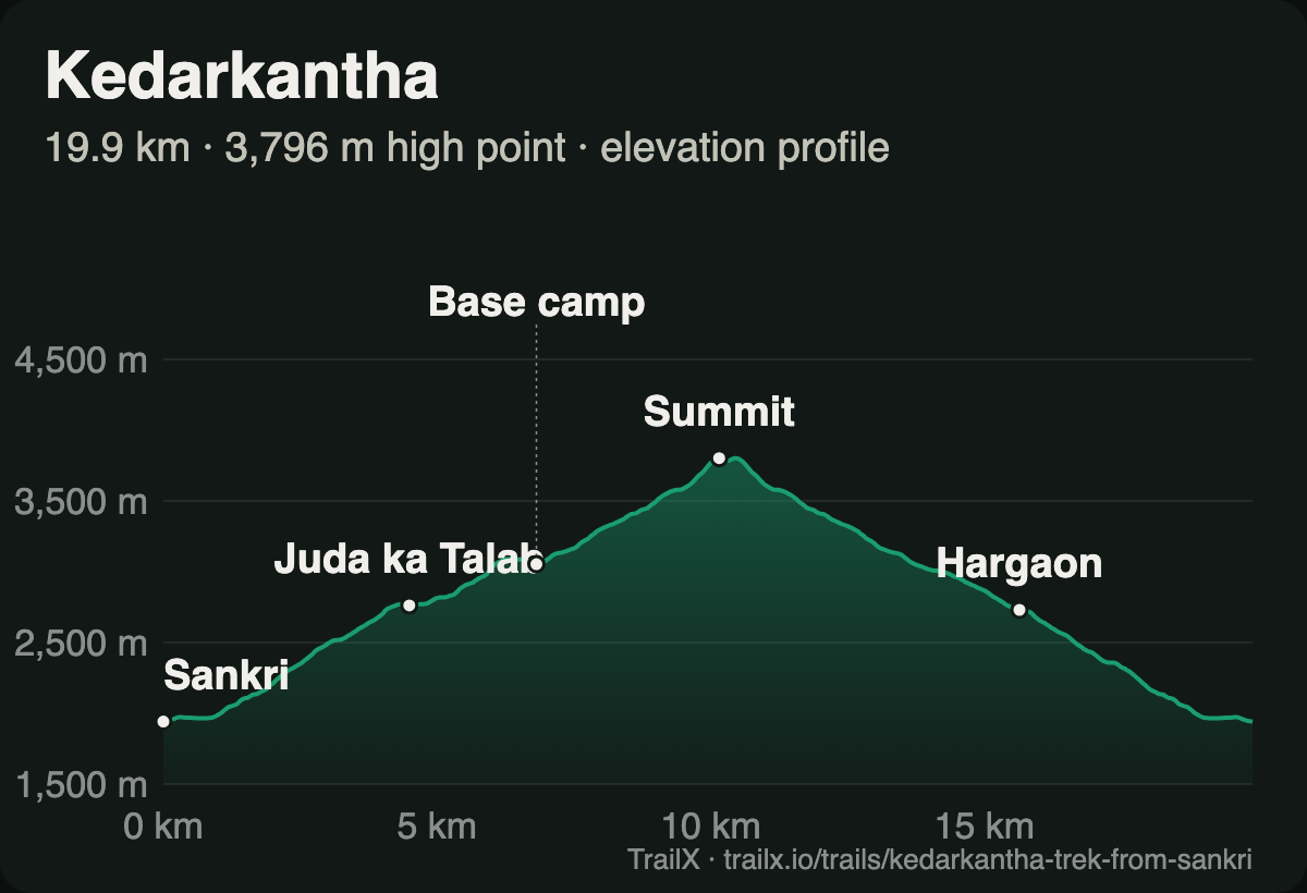 Elevation profile of the Kedarkantha Trek from Sankri: from about 1,950 m at Sankri through Juda ka Talab and the base camp to the 3,796 m summit, then down past Hargaon back to Sankri
What the terrain does. Our route is a loop of just under 20 km with about 1,860 m of climbing, and the profile is a near-perfect pyramid. The climb from Sankri to Juda ka Talab is steady forest walking. Above the base camp, the summit push is the steepest part of the trek: around 700 m in a few kilometres, usually started at 3 or 4 am so you reach the top for sunrise. In deep snow, this is where microspikes or crampons earn their place. The descent swings west to the Hargaon campsite and back down through the forest to Sankri.
What you see. From the summit, the whole of the upper Tons valley spreads out below you, with Swargarohini, Bandarpunch and Black Peak across the horizon, and the Har Ki Dun valley tucked into the mountains to the east.
- Route: Kedarkantha Trek from Sankri, 19.9 km loop, about 1,860 m of climbing, high point 3,796 m. New on TrailX.
- Best months: late December to March for snow; snow conditions vary a lot from year to year
- Permits: Govind Pashu Vihar National Park entry, paid at the forest office in Sankri and usually arranged by trek operators
- Fitness: good for a first Himalayan snow trek if you're fit enough to walk 6–8 km a day uphill with a pack
- Why go: the most rewarding summit day you can have in winter without technical climbing
2. Brahmatal: frozen lakes under Trishul
Brahmatal is the winter trek for people who want views from the first day to the last. From Lohajung, the roadhead on the way to Roopkund, the trail climbs through oak and rhododendron forest to the small lake of Bekal Tal, then onto a ridge facing two of Garhwal's great mountains, Trishul and Nanda Ghunti, and the long line of peaks behind them.
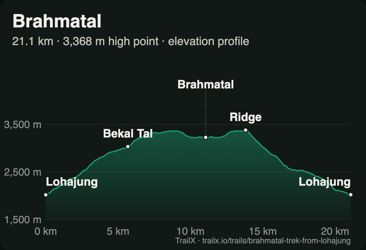 Elevation profile of the Brahmatal Trek from Lohajung: from about 2,300 m at Lohajung past Bekal Tal and up to a 3,368 m high point on the ridge before dropping to Brahmatal and back to Lohajung
What the terrain does. Our route is a 21 km loop with about 1,490 m of climbing. The first half is a steady climb through forest to Bekal Tal and on up to the ridge. Then the trail runs along it to Brahmatal, which sits in a shallow bowl and freezes over completely in midwinter. The return to Lohajung follows a second forest path. Many groups also climb the ridge above the lake for a closer look at Trishul.
What you see. In local legend, Brahma meditated beside this lake, and on a still winter morning it's easy to see why: a white bowl, a sheet of ice, and the biggest mountains in Garhwal lined up across the valley.
- Route: Brahmatal Trek from Lohajung, 21.1 km loop, about 1,490 m of climbing, high point 3,368 m. New on TrailX.
- Best months: December to March
- Permits: forest entry permits, usually arranged by trek operators in Lohajung
- Fitness: moderate; the ridge can be windy and icy, so carry microspikes and warm layers
- Why go: two frozen lakes and a front-row view of Trishul
3. Dayara Bugyal: a meadow the size of a sky
Dayara is one of the largest high meadows in the Indian Himalaya, a rolling grassland above Uttarkashi that's green in summer and an unbroken sweep of snow in winter. It's an ideal first winter trek: the climbing is steady, the campsites are beautiful, and the reward at the top is space as much as height.
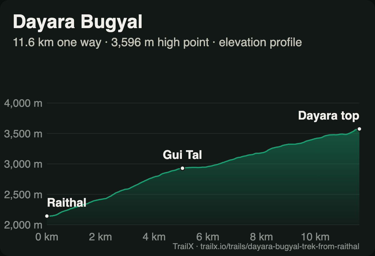 Elevation profile of the Dayara Bugyal Trek from Raithal: one long climb from about 2,140 m at Raithal past Gui Tal to the 3,596 m high point on Dayara top
What the terrain does. The TrailX route is a 22.9 km out-and-back from the village of Raithal with about 1,400 m of climbing, all of it on the way up. The profile is one long, even ramp: through forest to the small lake of Gui Tal at around 2,900 m, then out of the trees onto the open meadow and up to Dayara top at 3,596 m.
What you see. Bandarpunch and the Gangotri peaks across the valley, and on a clear winter day, a horizon of snow in every direction.
- Route: Dayara Bugyal Trek from Raithal, 22.9 km return, about 1,400 m of climbing, high point 3,596 m
- Best months: December to March for snow
- Permits: forest permits, usually arranged locally or by your operator
- Fitness: easy to moderate; one of the best winter treks for beginners
- Why go: the widest snow meadow you can walk to in a weekend
4. Kuari Pass: walking into the view
Kuari Pass, the old Curzon Trail, climbs from Joshimath past the ski slopes of Auli and through the meadows of Gorson to a ridge facing Nanda Devi, Dunagiri and Kamet. In winter, the whole route is under snow, and it becomes one of the classic snow treks of Uttarakhand. We covered it in detail in Trails That Lead to Heaven.
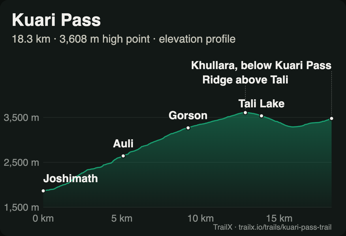 Elevation profile of the Kuari pass trail: from about 1,860 m at Joshimath through Auli and Gorson to a 3,608 m high point on the ridge above Tali Lake, then down to Khullara
What the terrain does. This route climbs about 1,940 m in 18 km, almost all of it in the first 13. In winter, the steep first section to Auli can be icy, and above Gorson the snow can be knee-deep after a storm.
- Route: Kuari pass trail, 18.3 km one way, about 1,940 m of climbing, high point 3,608 m, recorded by fakir27
- Best months: December to March for snow
- Permits: check forest permits and camping rules locally
- Fitness: moderate; harder than Kedarkantha in deep snow
- Why go: the finest Nanda Devi view you can reach on foot in winter
5. Nag Tibba: the weekend snow summit
Nag Tibba, "serpent's peak", is the highest point of a range in the lower Himalaya, a few hours' drive from Dehradun and Mussoorie. It's the shortest Himalayan snow summit in this guide, and the most popular weekend trek out of Delhi in winter.
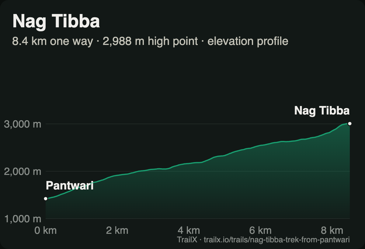 Elevation profile of the Nag Tibba Trek from Pantwari: a steady climb of about 1,550 m from Pantwari to the 2,988 m summit
What the terrain does. The route is a 16.9 km out-and-back from Pantwari, and it's steeper than it looks: about 1,550 m of climbing in 8.5 km. The trail climbs past terraced fields and through oak forest to a meadow near the Nag Devta temple, where most groups camp, then on to the summit at about 3,000 m. Water is scarce on the upper trail.
What you see. Bandarpunch, Swargarohini, Kalanag and the Gangotri peaks from the top, and in the other direction, the lights of the Doon valley.
- Route: Nag Tibba Trek from Pantwari, 16.9 km return, about 1,550 m of climbing, high point 2,988 m. New on TrailX.
- Best months: December to February for snow
- Permits: forest entry permit, arranged in Pantwari or by your operator
- Fitness: easy to moderate; one steep day up, one down
- Why go: a Himalayan snow summit in two days
6. Deoria Tal: the lake that holds Chaukhamba
The shortest walk in this guide is also one of the most beautiful. From the village of Sari, a stone path climbs through oak forest to Deoria Tal, a lake whose still surface reflects the four summits of Chaukhamba on a calm morning. In winter, the meadow around it is often under snow, and the lake may freeze at the edges.
- Route: Deoria Tal, 1.8 km one way, about 330 m of climbing, high point 2,385 m
- Best months: December to March
- Permits: a small forest entry fee at the trailhead; camping at the lake is restricted, so check before planning a night there
- Fitness: easy; families walk it
- Why go: a big Himalayan view for a two-hour climb
Deoria Tal is often combined with Chopta, Tungnath and Chandrashila in winter. The Tungnath temple is closed in winter, and the road to Chopta can be blocked by snow after a storm. See our guide to the lakes of Uttarakhand for more on Deoria Tal and the high tarns around it.
7. Har Ki Dun: the valley of the gods in snow
Har Ki Dun is usually walked in spring and autumn, when the wooden villages of Seema and Osla are busy with farming. In winter, the valley is quieter and colder, and above Osla the trail is under snow. It's a long trek for winter, so go with an operator who knows the conditions. We described it in Trails That Lead to Heaven.
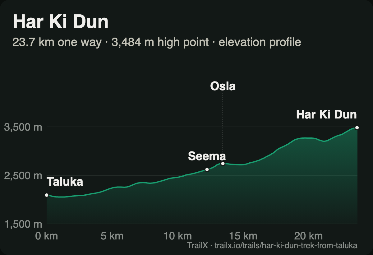 Elevation profile of the Har Ki Dun Trek from Taluka: a gradual climb from about 2,100 m at Taluka through Seema and Osla to Har Ki Dun at about 3,500 m
- Route: Har Ki Dun Trek from Taluka, 47.4 km return, about 1,680 m of climbing, high point 3,484 m
- Best months: December to March for snow, if conditions allow; April–June and September–November otherwise
- Permits: Govind Pashu Vihar National Park, paid at the forest office in Sankri
- Fitness: moderate, but long; expect five or six days
- Why go: centuries-old wooden villages and a snowbound valley under Swargarohini
8. Sandakphu–Phalut: four of the world's five highest mountains
Sandakphu, at 3,636 m the highest point in West Bengal, sits on the Singalila ridge right on the India–Nepal border. From its top, on a clear morning, you can see Everest, Lhotse, Makalu and Kangchenjunga: four of the five highest mountains on Earth, with the long white shape of the "Sleeping Buddha" range in front of you. Winter brings the clearest skies of the year, and sometimes snow on the ridge.
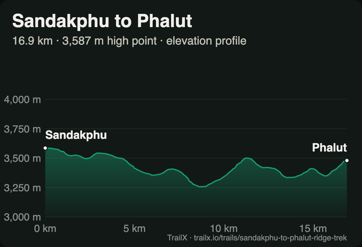 Elevation profile of the Sandakphu to Phalut Ridge Trek: a rolling ridge walk between about 3,250 m and 3,590 m from Sandakphu to Phalut
What the terrain does. Most trekkers walk or ride up from Manebhanjan to Sandakphu, a climb of about 2,350 m over 31 km on the old Land Rover road. Beyond Sandakphu, the ridge walk to Phalut is the quietest and finest part of the trek: 16.9 km through open grassland and dwarf rhododendron, rolling between about 3,250 and 3,590 m, with the mountains in view almost all the way.
- Routes: Sandakphu to Phalut Ridge Trek, 16.9 km one way, about 560 m of climbing, high point 3,587 m; Manebhanjan to Sandakphu Land Rover Road, 31.1 km, about 2,350 m of climbing
- Best months: October to March; December and January are coldest, with the clearest views
- Permits: Singalila National Park entry at Manebhanjan; a registered guide is required inside the park. The trail crosses into Nepal in places, so carry photo ID
- Fitness: moderate; lodges and homestays mean you don't need to carry camping gear
- Why go: the best view of the Everest massif from Indian soil
High-altitude winter adventures
The two trips in this section aren't winter hikes. They're expeditions into some of the coldest inhabited places on Earth, with strict rules, limited access, and real consequences if things go wrong. Treat them as specialist trips: go with an experienced, registered operator, and check the current rules before you book anything.
9. Chadar: walking on the frozen Zanskar
For a few weeks each winter, the Zanskar river freezes along the floor of its gorge, and the ice, the chadar or "blanket", becomes a path. For centuries it was the only winter route out of Zanskar. Today it's one of the most famous treks in the world: days of walking and sliding on ice between walls of rock, nights in caves and tents at −20 °C and below, and frozen waterfalls hanging from the canyon walls.
It has also become one of the least predictable. In recent winters, the Leh administration has delayed the start of the season because the river hadn't frozen thick enough, and construction of the Nimu–Padum–Darcha road along the gorge has cut the trek from its old length to a much shorter walk of two or three days on the ice. The administration sets the rules each season: treks are run only through registered operators, trekkers must spend several days acclimatising in Leh and pass a medical check before setting out, and the trek can be stopped at short notice when the ice is unsafe.
- Route: none on TrailX. The safe line on the ice changes from day to day, and following an old GPS track on a frozen river would be dangerous. Your guide reads the ice, not the map
- Best months: mid-January to February, if and when the ice is declared safe
- Permits: arranged by your registered operator with the Leh administration; check the current season's rules before you book flights
- Fitness: good fitness, cold-weather experience and the right gear are essential
- Why go: there is nothing else like it, anywhere
10. Spiti in winter: the cold desert under snow
In winter, Spiti closes in on itself. The Kunzum Pass road is shut, the only way in is the long road up from Shimla through Kinnaur, and the villages at 3,600 to 4,500 m sit under snow at temperatures that fall to −25 °C at night. It's also when Spiti is at its most magical: frozen streams, white-walled monasteries against blue skies, and in the high villages around Kibber, the best chance of the year to see a snow leopard.
Winter in Spiti is about short walks from a warm homestay, not long treks. The walk up to Dhankar Lake above Dhankar monastery is one of the best: 2.5 km and about 290 m of climbing to a small lake at 4,129 m, with the Spiti and Pin valleys below. For the full journey there, the Spiti Valley Circuit traces the road from Shimla through Kinnaur to Kaza; in winter, only the Kinnaur side is open.
- Routes: Dhankar Lake, 2.5 km one way, high point 4,129 m; Spiti Valley Circuit for the road
- Best months: January to March for the full winter experience
- Permits: foreign nationals need an Inner Line Permit for parts of the Kinnaur–Spiti road; check road status before every leg
- Fitness: the altitude and cold are the challenge, not the walking: acclimatise for at least two days in Kaza before walking uphill
- Why go: snow leopards, silence, and the Himalaya at its starkest
For more on the high lakes of the region, see Lakes of Himachal.
Winter hiking beyond the Himalayas
When the north freezes, the Western Ghats come into their own. From November to February, the Sahyadri of Maharashtra and the hills of Karnataka and Kerala have their clearest, coolest, driest weather of the year. None of these hikes needs snow gear, and most can be done in a day. What they need instead is an early start, plenty of water, and, in Karnataka and Kerala, an advance booking and a forest guide.
11. Kalsubai: the roof of Maharashtra
Kalsubai, at 1,646 m, is the highest peak in Maharashtra. From the village of Bari, the trail crosses farmland and grassy slopes and then climbs a series of iron ladders and rock steps to a small temple at the summit, with views over Bhandardara lake and the forts of the Sahyadri.
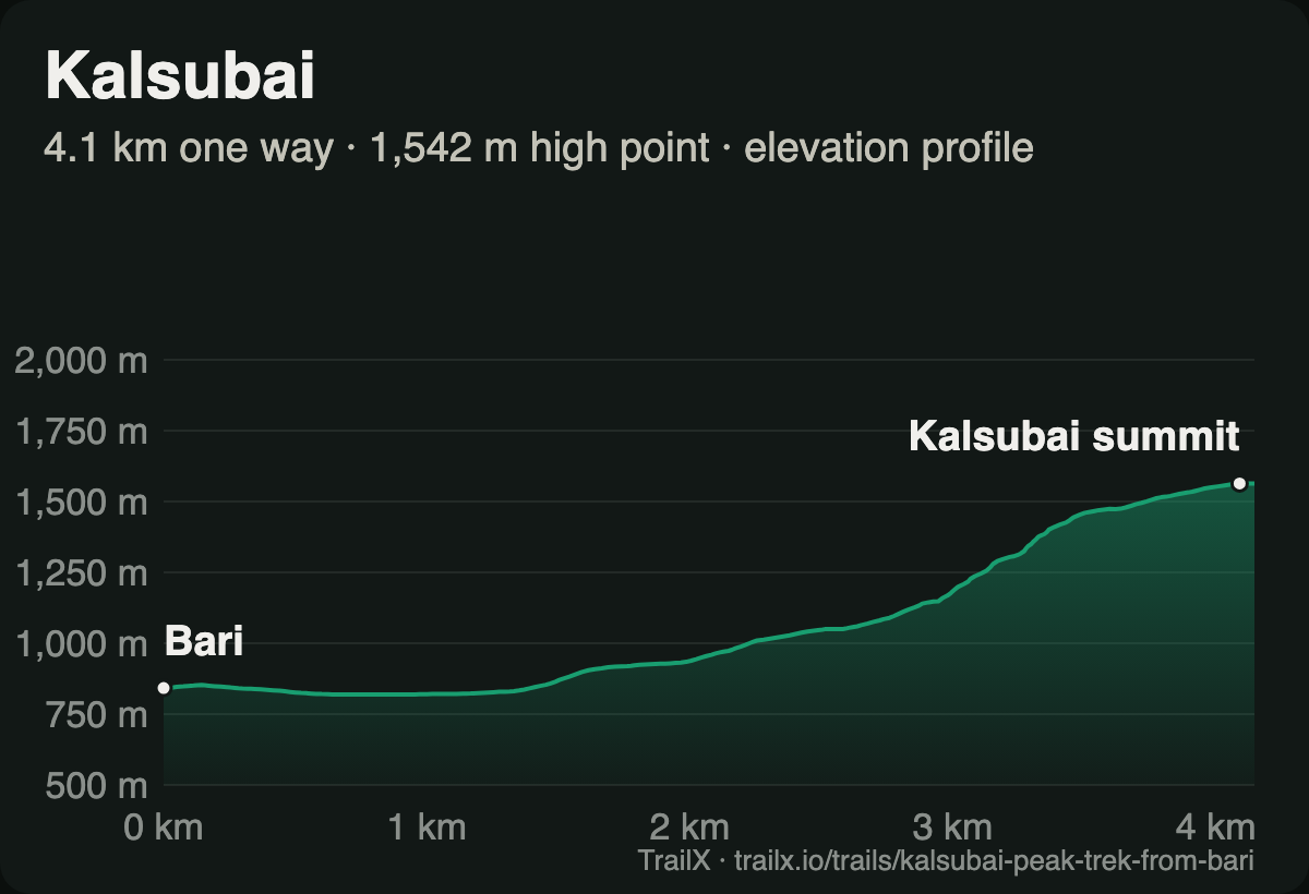 Elevation profile of the Kalsubai Peak Trek from Bari: gentle for the first 2 km from Bari at about 840 m, then a steep climb to the summit
What the terrain does. The route is 8.2 km return with about 750 m of climbing. The first couple of kilometres from Bari are nearly flat; then the trail turns uphill and doesn't let up, with the ladders on the steepest sections near the top. In winter, many hikers start at 3 or 4 am to watch sunrise from the summit.
- Route: Kalsubai Peak Trek from Bari, 8.2 km return, about 750 m of climbing. New on TrailX.
- Best months: November to February
- Permits: none for the Bari trail; Kalsubai lies in the Kalsubai Harishchandragad Wildlife Sanctuary, so sanctuary rules apply
- Fitness: moderate; the ladders are exposed and get crowded on weekends
- Why go: a sunrise from the highest point in Maharashtra
12. Rajmachi: twin forts on a forest plateau
Rajmachi is the gentlest walk in this guide and one of the most satisfying. From Tungarli, just outside Lonavala, a dirt track runs for about 14 km across the plateau through forest and open grassland to Udhewadi, the village at the foot of the twin forts of Shrivardhan and Manaranjan.
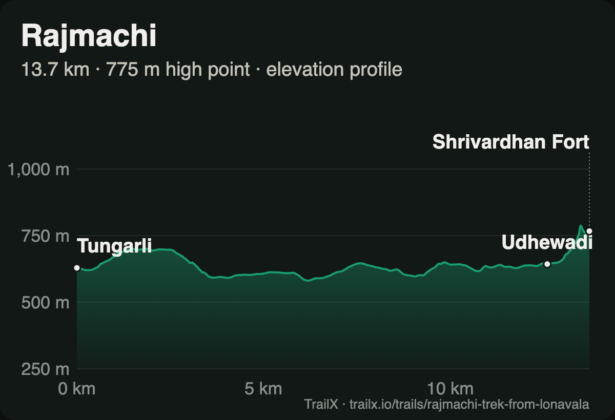 Elevation profile of the Rajmachi Trek from Lonavala: a nearly level walk between about 580 m and 700 m from Tungarli to Udhewadi, then a short climb to Shrivardhan Fort at 775 m
What the terrain does. The profile is almost flat: only about 350 m of climbing in 13.7 km, most of it in the short final climb to Shrivardhan Fort. Many people stay overnight in Udhewadi and walk back the next morning. If you want a steeper climb, the trail from Kondivade on the Karjat side reaches the village in a few hours.
- Routes: Rajmachi Trek from Lonavala, 13.7 km one way, about 350 m of climbing. New on TrailX. For riders and drivers, the Rajmachi Off-Road Trail runs from Pune
- Best months: November to February
- Permits: none
- Fitness: easy; a long but gentle day
- Why go: two forts, a village homestay and the Konkan at your feet
13. Kudremukh: the horse-faced peak
Kudremukh, "horse face" in Kannada, rises at about 1,890 m above some of the finest shola grassland left in the Western Ghats. The trail from Mullodi crosses streams, rolls over hill after grassy hill, and passes the lone tree at Ontimara before the final climb to the summit.
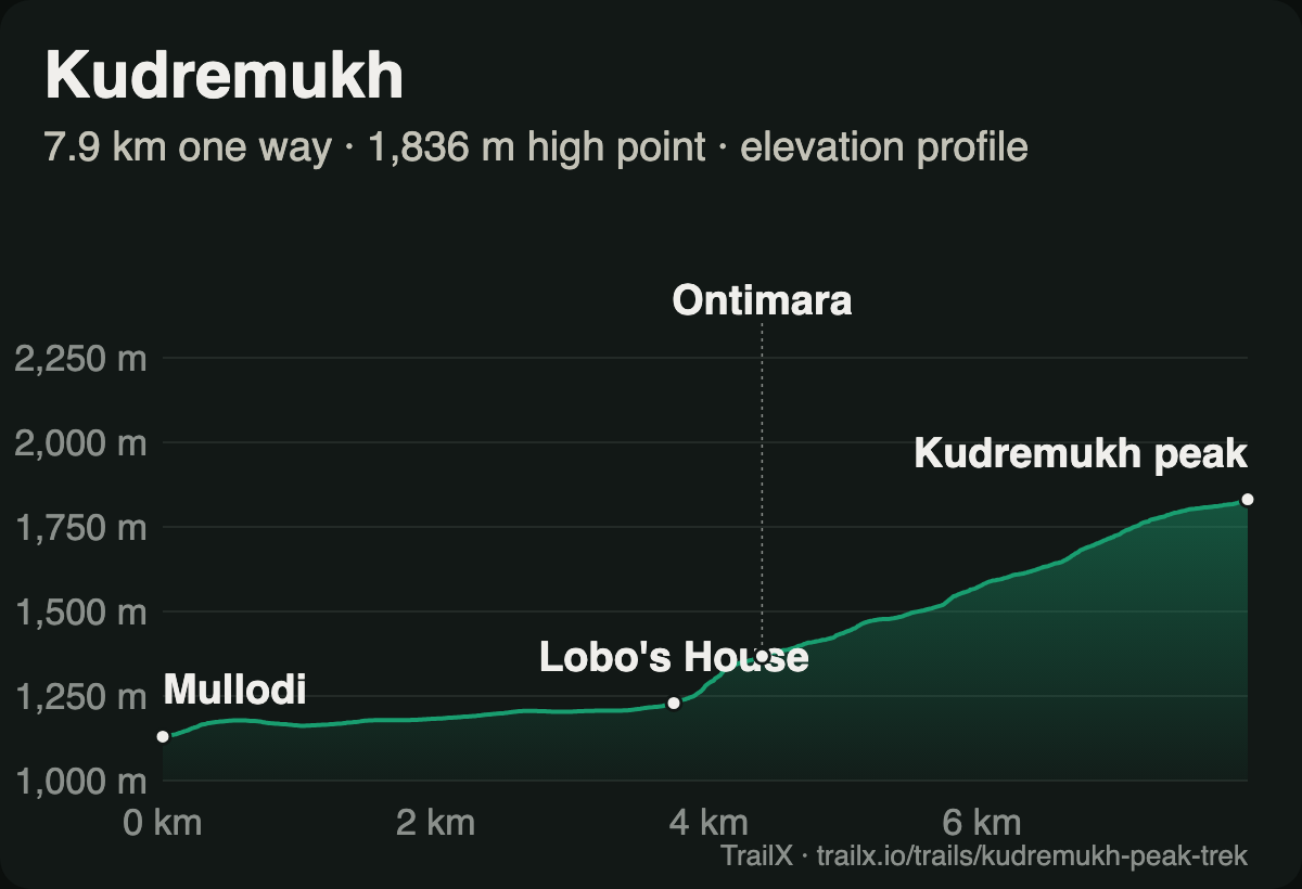 Elevation profile of the Kudremukh Peak Trek: from Mullodi at about 1,130 m past Lobo's House and Ontimara to the summit, at about 1,840 m on the track
What the terrain does. The route is 16.6 km return with about 810 m of climbing, spread evenly over the 8 km to the top. It's long rather than steep, and in winter the grass is dry, the streams are low, and the views run all the way to the Arabian Sea on a clear day.
- Route: Kudremukh Peak Trek, 16.6 km return, about 810 m of climbing
- Best months: October to January
- Permits: advance online booking through the Karnataka Forest Department's Aranya Vihaara portal; no spot bookings, and the ID used to book must be shown at the start. A certified nature guide is mandatory
- Fitness: moderate; a full day
- Why go: the most beautiful grassland walk in South India
14. Tadiandamol: the summit of Coorg
Tadiandamol, at about 1,750 m, is the highest peak in Kodagu. The trail starts at Nalknad Palace, an 18th-century palace of the rajas of Coorg, and climbs through coffee estates and shola forest onto an open grassy ridge that leads to the rocky summit.
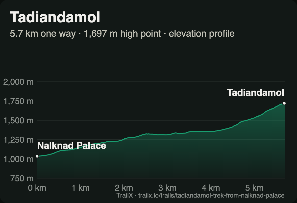 Elevation profile of the Tadiandamol Trek from Nalknad Palace: a steady climb from about 1,040 m to the summit, at about 1,700 m on the track
What the terrain does. The route is 11.3 km return with about 670 m of climbing: a steady climb on a jeep track and forest path, then a grassy ridge with a short, steep finish. In the dry winter months, the summit looks out over the green folds of Coorg to the Kerala hills.
- Route: Tadiandamol Trek from Nalknad Palace, 11.3 km return, about 670 m of climbing. New on TrailX.
- Best months: October to February
- Permits: Karnataka now requires certified nature guides on all Forest Department trekking routes and is moving them onto online booking. Check the Aranya Vihaara portal for Tadiandamol's current rules before you go
- Fitness: easy to moderate
- Why go: Coorg from the top, in half a day
15. Chembra: the heart-shaped lake
Chembra is the highest hill in Wayanad, and halfway up it sits a small lake shaped almost perfectly like a heart, Hridaya Saras. From the forest ticket counter above Meppadi, the trail follows an estate road through tea plantations, then climbs steep grassy slopes past a watchtower to the lake.
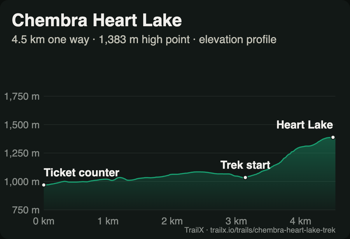 Elevation profile of the Chembra Heart Lake Trek: from about 970 m at the ticket counter through the tea estates to the trek start, then a steep climb to the Heart Lake
What the terrain does. The route is 9 km return with about 500 m of climbing. The first half, through the tea estates, is easy. Above the trek start, the grassy slope is short and steep, and slippery after rain. The trail beyond the lake to the summit has been closed to visitors, so the lake is where the trek ends.
- Route: Chembra Heart Lake Trek, 9.0 km return, about 500 m of climbing. New on TrailX.
- Best months: September to February
- Permits: tickets from the Meppadi forest office or Kerala Forest ecotourism; groups trek with a forest guide and daily numbers are capped, so arrive early
- Fitness: easy
- Why go: tea gardens, a heart-shaped lake and all of Wayanad below you
Best winter treks for beginners
If this is your first winter trek, pick one where the days are short, the trail is well trodden and help is close:
- Dayara Bugyal and Nag Tibba for a first taste of Himalayan snow. Both have steady climbing, good campsites and no technical sections.
- Kedarkantha and Brahmatal for a first Himalayan summit or ridge. Go with an operator, and expect one hard summit day.
- Deoria Tal for a family walk to a big view.
- Sandakphu for a lodge-to-lodge trek without camping gear.
- Rajmachi, Chembra and Tadiandamol for a first trek without snow.
Best winter treks for experienced trekkers
- Kuari Pass in deep snow, when the Gorson meadows are hard going and the pass is a real winter objective.
- Har Ki Dun in winter, for a long, cold, quiet valley trek.
- Chadar, for those with cold-weather experience and a registered operator.
- Spiti in winter, for the cold, the altitude and the chance of a snow leopard.
- Kudremukh, for the longest day in the Western Ghats.
Winter trekking essentials and safety
Winter trekking in the Himalaya isn't harder than summer trekking. It's different, and the differences catch people out.
- Snow hides the trail. A path that's obvious in October can disappear under a single storm. Go with a guide on Himalayan treks, and carry the route on your phone as a backup.
- Days are short. You'll have about ten hours of daylight in December. Start early, and plan to be in camp by 3 pm.
- Cold drains everything. Phone and camera batteries can lose half their charge in an hour of cold. Keep them inside your jacket, and carry a power bank.
- Water freezes. Carry an insulated bottle, and sleep with your water inside your tent.
- Altitude still counts. Kedarkantha, Brahmatal and Kuari all reach above 3,300 m. Spiti and Chadar are higher still. Climb slowly, drink plenty, and turn back if symptoms of altitude sickness get worse. Read how to cross a high pass safely before you go.
- Watch the weather. A western disturbance can bring a metre of snow in two days. Our guide to reading weather charts can help with go or no-go calls.
- In the Ghats, the risk is heat and getting lost. Start before sunrise, carry two to three litres of water, and stay with your guide on Forest Department routes.
Winter packing checklist
For the Himalayan snow treks:
- Layers: thermal base layers, a fleece, a down or synthetic insulated jacket, and a waterproof, windproof shell
- Extremities: a warm hat, a balaclava or buff, liner gloves and insulated waterproof gloves, and two or three pairs of wool socks
- Feet: waterproof trekking boots with ankle support, gaiters, and microspikes for icy sections
- Sleeping: a sleeping bag rated to about −10 °C; many operators provide one
- Sun: dark sunglasses or glacier glasses (snow blindness is real), sunscreen and lip balm
- Other: trekking poles, a headlamp with spare batteries, an insulated water bottle, a power bank and a small first-aid kit
For the Western Ghats: light layers for cold mornings, a sun hat, two to three litres of water, sturdy shoes with good grip, a headlamp for a sunrise start, and your booking confirmation and ID.
How to plan and navigate your winter trek
- Book early for the Himalaya. January dates for Kedarkantha and Brahmatal are the most popular of the year and fill up early.
- Check access and permits. Forest permits, national park entry, Karnataka's online bookings and Chadar's seasonal rules all change. Confirm them before you travel.
- Download the GPX. Each route above is on TrailX: open the trail page and download the GPX for your watch or navigation app. Here's how.
- Read the profile. Each trail page shows the elevation profile, so you know where the climbing comes. See how to read an elevation profile.
- Go offline. There's no phone signal on most of the Himalayan treks above the roadhead. Save the route for offline use in the TrailX app before you leave.
Find your next winter trail
There's a moment on every winter trek when you stop at the top of a climb, breathe the cold air, and realise you're the only people for miles in a world gone white and silent. You can't download that. But you can see what's coming.
Open any of these routes in the free TrailX app for iPhone or Android, tap the preview button on the map, and fly the whole trek in 3D on the real terrain: every ridge, every lake, every summit. Here's how the 3D flyover works.
Pick your trail, check the snow, and go and find out what the mountains look like in winter.
Written by
fakir27
TrailX scout with more than 90 mapped routes, from the Trans Uttarakhand Shiva Trail to the roads to Kailash and Lipulekh.
Responses