On this page
- 01Five treks, one mountain wall
- 02The five treks at a glance
- 031. Valley of Flowers: the garden at the end of the gorge
- 042. Kuari Pass: walking into the view
- 053. Har Ki Dun: the valley of the gods
- 064. Rupin Pass: the crossing
- 075. Kashmir Great Lakes: seven lakes and three passes
- 08Before you go
- 09See it before you go
The first thing you notice is the quiet. Not silence, exactly: there's a stream somewhere below, the clink of a mule's bell on the path behind you, wind combing through grass that hasn't been cut in a thousand years. But the noise of the world you came from is gone, and for a while your own breathing is the loudest thing in the valley.
Then the trail turns a corner. The forest falls away, the ridge opens, and the mountains you've been walking towards for two days are suddenly there: not on a postcard, not on a screen, but filling half the sky. Ask anyone who has done a Himalayan trek what they remember, and it's usually a moment like that. A lake that appears below a pass like a dropped mirror. A meadow so full of flowers you're afraid to step off the path. A village of carved wooden houses that looks as if it has been waiting for you.
Some trails lead to a summit. These five lead somewhere harder to describe. The local names give it away: Har Ki Dun, the valley of the gods, below Swargarohini, the stairway the Pandavas climbed to heaven. Gangabal, the sacred lake at the end of the Kashmir Great Lakes. The Valley of Flowers, which pulled the mountaineer who stumbled into it back across the world six years later, just to collect its plants.
This is a guide to how those journeys actually unfold: what the ground looks like, where the climbing comes, and what waits around the next ridge. Every route here is a real TrailX route you can open, download and fly through in 3D before you go.
Five treks, one mountain wall
Strung along the map from northwest to southeast, these five treks follow the great wall of the western Himalaya for some 600 km.
In the far north, the Kashmir Great Lakes trek crosses the high country between Sonamarg and the slopes of Mount Harmukh, where glacial lakes lie in chains across meadows above 3,500 m. Far to the southeast, on the border of Himachal Pradesh and Uttarakhand, Rupin Pass climbs from the apple orchards of Kinnaur over a snow saddle and down into a valley of waterfalls. Just southeast of it, Har Ki Dun follows the Supin river up into Garhwal's Tons valley, to a meadow at the foot of Swargarohini. And at the eastern end, around Joshimath, Kuari Pass and the Valley of Flowers sit on either side of the Alaknanda, facing the highest mountain wholly inside India, Nanda Devi.
They make a natural progression, too. The Valley of Flowers is a long day's walk to a garden. Kuari Pass is a short trek built around a view. Har Ki Dun is a slow walk back in time. Rupin Pass is a proper crossing, and the Kashmir Great Lakes is a week-long journey across three passes. That's the order we follow below.
The five treks at a glance
| Trek | Where | TrailX route | Distance | Climbing | High point | Best season |
|---|---|---|---|---|---|---|
| Valley of Flowers | Chamoli, Uttarakhand | Valley of Flowers Trek from Pulna | 15.5 km one way | 1,450 m | 3,537 m | July–August for flowers |
| Kuari Pass | Chamoli, Uttarakhand | Kuari pass trail | 18.3 km one way | 1,940 m | 3,608 m | December–March for snow; April–May, October–November for views |
| Har Ki Dun | Uttarkashi, Uttarakhand | Har Ki Dun Trek from Taluka | 47.4 km return | 1,680 m | 3,484 m | April–June, September–November |
| Rupin Pass | Kinnaur, Himachal Pradesh, to Uttarkashi | Rupin Pass Trail | 76.6 km | 2,770 m | 4,560 m | Mid-May–June, mid-September–October |
| Kashmir Great Lakes | Ganderbal, Jammu and Kashmir | Kashmir Great Lakes Trek: Sonamarg to Naranag | 67.8 km | 2,960 m | 4,183 m | July–mid-September |
About the numbers. Distances, climbing and heights come from each route's GPS track and TrailX's terrain data, so they can differ from the round figures on signs and in trek brochures, usually by 50–100 m on heights. Each trek below has an elevation profile drawn from its track, and a 3D view of the route on real terrain.
The Kuari Pass route was recorded on the trail by TrailX scout fakir27, who also mapped the Rupin Pass route. We mapped the Kashmir Great Lakes and Har Ki Dun routes along OpenStreetMap trails for this guide. Street View isn't available on any of these five: there aren't enough street-level photos this high in the mountains yet. The 3D flyover works on all of them.
1. Valley of Flowers: the garden at the end of the gorge
In 1931, the mountaineer Frank Smythe was coming down from the first ascent of Kamet when he and his companions crossed the Bhyundar pass and came down into a valley full of flowers. He came back to collect them, and his book named the place for the world: the Valley of Flowers.
The trail there starts at Pulna, the roadhead above Govindghat, and begins as a stone-paved mule path up the gorge of the Lakshman Ganga. For the first few hours it's a busy, cheerful walk: pilgrims bound for Hemkund Sahib, ponies, porters with baskets, tea stalls at every bend. Then you reach Ghangaria, the last village, and the crowd splits. The pilgrims turn uphill for Hemkund. You cross the Pushpawati river into the national park, and the valley opens out ahead of you.
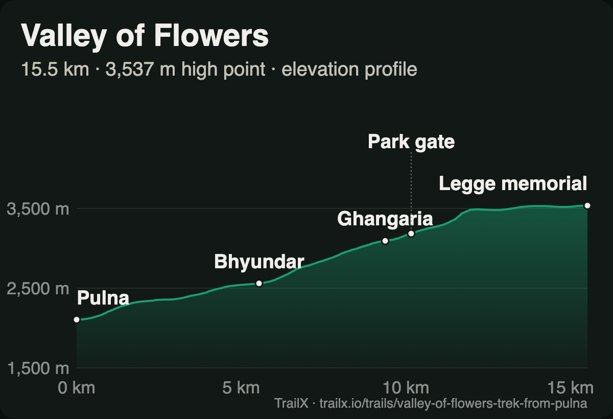 Elevation profile of the Valley of Flowers Trek from Pulna: from about 2,100 m at Pulna through Bhyundar and Ghangaria to about 3,500 m inside the valley
What the terrain does. The profile is one long, steady ramp: about 1,450 m of climbing in 15.5 km, with no real descents. The first 9 km to Ghangaria do most of the work, climbing from around 2,100 m to 3,000 m on a wide, stepped path. Past the park gate, the trail climbs again through birch and boulders, then flattens onto the valley floor at around 3,500 m. That's the moment it changes: the walls of the gorge pull back, the valley floor widens into a meadow several kilometres long, and on either side the slopes rise to snow.
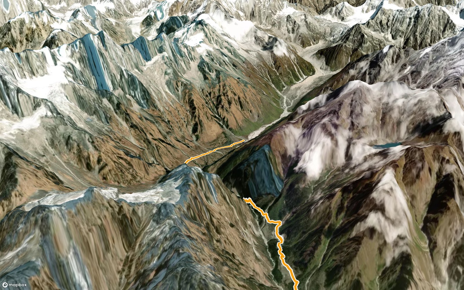 3D view of the Valley of Flowers route from Ghangaria into the Bhyundar valley, the trail in orange on satellite terrain
What waits around the next ridge. In late July, flowers: blue poppies, cobra lilies, potentillas, geraniums and primulas, hundreds of species in all, under a ring of glaciers. Halfway up the valley is the grave of Joan Margaret Legge, a botanist from Kew Gardens who came to collect plants in 1939 and died after a fall. Her sister put up a memorial to her there, and it's where our route ends.
- Route: Valley of Flowers Trek from Pulna, 15.5 km one way, 1,450 m of climbing, rated Hard
- Season: the park is open roughly June to October; the flowers peak from mid-July to mid-August, which is also the monsoon
- Access: an entry permit from the forest post at Ghangaria; day visits only, with no camping inside the valley
- Why go: few walks anywhere put this much colour this close to the snow
For the lake above Ghangaria and other high tarns of the region, see our guide to the lakes of Uttarakhand.
2. Kuari Pass: walking into the view
Kuari Pass is sometimes called the Curzon Trail, after the Viceroy whose party used the route in the early 1900s. It doesn't need the history. It has one of the finest mountain panoramas you can reach on foot in India: Nanda Devi, Dunagiri, Kamet, Hathi Ghoda and a long line of Garhwal giants, spread across the horizon from a grassy ridge.
The route we feature here is a real GPS track, recorded on the trail by fakir27. It starts in Joshimath, climbs on foot to the ski slopes of Auli, and keeps going: through oak and rhododendron forest to the meadows of Gorson, up a long ridge above Tali Lake, and down through forest to the campsite at Khullara, below the pass itself.
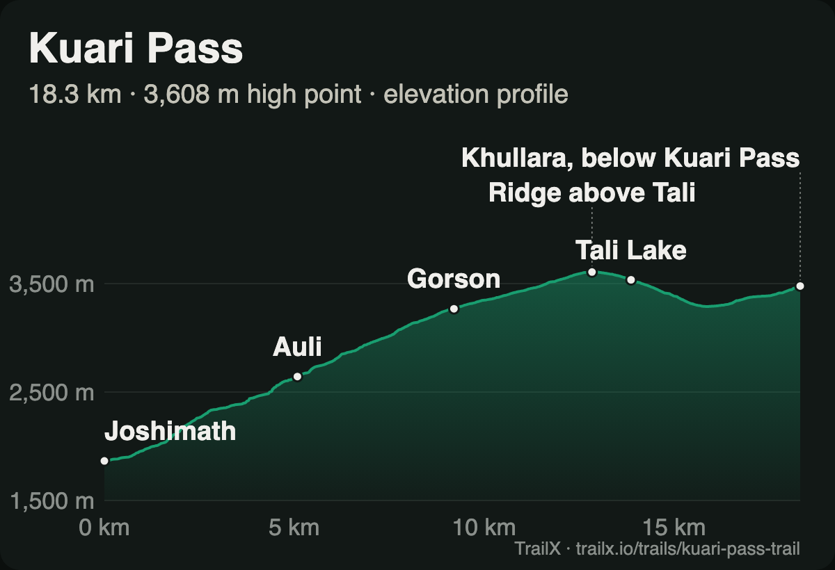 Elevation profile of the Kuari pass trail: from about 1,860 m at Joshimath through Auli and Gorson to a 3,608 m high point on the ridge above Tali Lake, then down to Khullara
What the terrain does. This route climbs nearly 1,950 m in 18 km, almost all of it in the first 13. The first stretch out of Joshimath is the steepest, switchbacking up to Auli at about 2,650 m. From there the gradient eases into the open slopes of Gorson Bugyal, and the forest thins until you're walking along a broad ridge. The high point, 3,608 m, is on that ridge above Tali Lake. Then the trail drops about 300 m through forest before climbing again to Khullara. The track stops there, about 0.6 km and 200 m below the pass, which most trekkers climb at dawn from the camp.
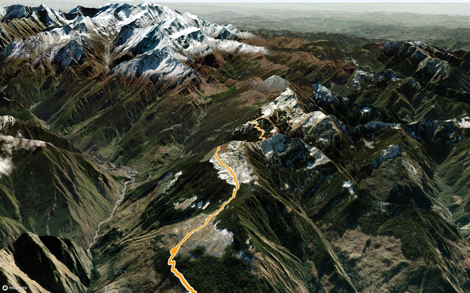 3D view of the Kuari pass trail along the ridge above Tali, the trail in orange on satellite terrain
What waits around the next ridge. On a clear morning from the pass, the whole Nanda Devi sanctuary rim lines up in front of you. In winter, the same slopes are under deep snow, and Kuari becomes one of the classic snow treks of Uttarakhand.
- Route: Kuari pass trail, 18.3 km one way, about 1,940 m of climbing, rated Hard
- Season: December to March for snow; April–May and October–November for the clearest views
- Access: usually done as a 4- to 6-day trek; check forest permits and camping rules locally
- Why go: maximum mountain view for minimum altitude
3. Har Ki Dun: the valley of the gods
Some treks are about getting high. Har Ki Dun is about going back. From the roadhead at Taluka, the trail follows the Supin river upstream into a valley where villages are built of stone and deodar wood, carved with flowers and horses, their roofs weighed down with slate. By local tradition, some of these villages still honour Duryodhana, the antihero of the Mahabharata, at their temples. The epic is everywhere here. At the head of the valley stands Swargarohini, the "stairway to heaven" that, in the story, the Pandavas climbed at the end of their lives.
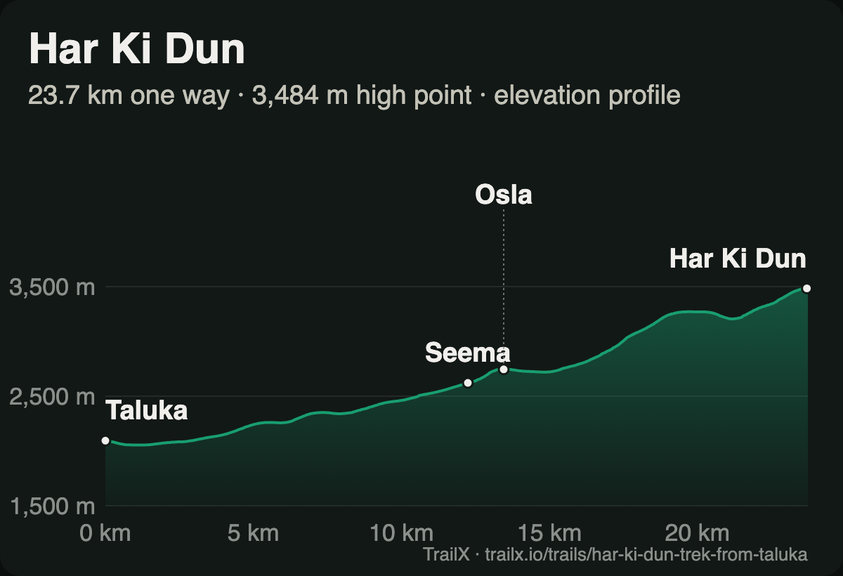 Elevation profile of the Har Ki Dun Trek from Taluka, one way: from about 2,100 m at Taluka past Seema and Osla to about 3,500 m at Har Ki Dun
What the terrain does. Har Ki Dun is the gentlest climb in this guide: about 1,500 m spread over the 23.7 km up the valley, so you're rarely breathing hard. The first 12 km to Seema stay close to the river through walnut, chestnut and pine, gaining only about 500 m. Past Osla, the trail crosses to the north side and starts climbing steadily through terraced fields, then high pastures. In the last few kilometres the valley bends and opens into the meadow of Har Ki Dun, at about 3,500 m, framed by snow peaks on three sides.
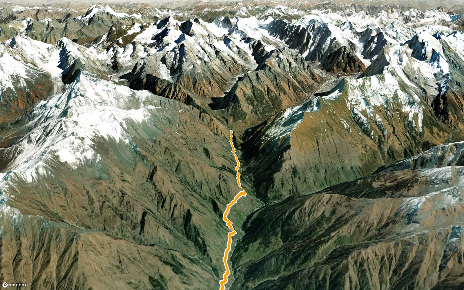 3D view of the Har Ki Dun trail climbing into the meadow, with the snow peaks at the head of the valley, the trail in orange on satellite terrain
What waits around the next ridge. Swargarohini at sunrise, turning gold above the meadow. From the meadow, day walks lead up to the Jaundhar glacier and the small lake of Maninda Tal. And on the way back down, there's time for Osla: the old houses, the temple, the people who still farm these slopes.
- Route: Har Ki Dun Trek from Taluka, 47.4 km return, 1,680 m of climbing, rated Hard. New on TrailX.
- Season: April to June and September to November; snow covers the upper valley in winter
- Access: Govind Pashu Vihar National Park entry permits and fees, paid at the forest office in Sankri
- Why go: a high Himalayan valley where the culture is as remarkable as the mountains
From Seema, a side valley leads to Ruinsara Tal, another TrailX route.
4. Rupin Pass: the crossing
Rupin is the trek in this guide where the landscape changes the most, and the fastest. On one side of the pass are the apple orchards and slate-roofed villages of Kinnaur; on the other, a valley that drops in tiers of waterfalls, snow bridges and meadows to villages that cling to cliffs.
fakir27's route crosses it from east to west. From Sangla, it climbs steeply to the high meadows of Sangla Kanda, then up through boulder fields and snow to Rupin Pass. On the far side, it descends past the Rupin waterfall to the camp at Dhanderas Thach, and then follows the Rupin river down through Jiskun and Dodra-Kwar to the Tons valley and Sankri.
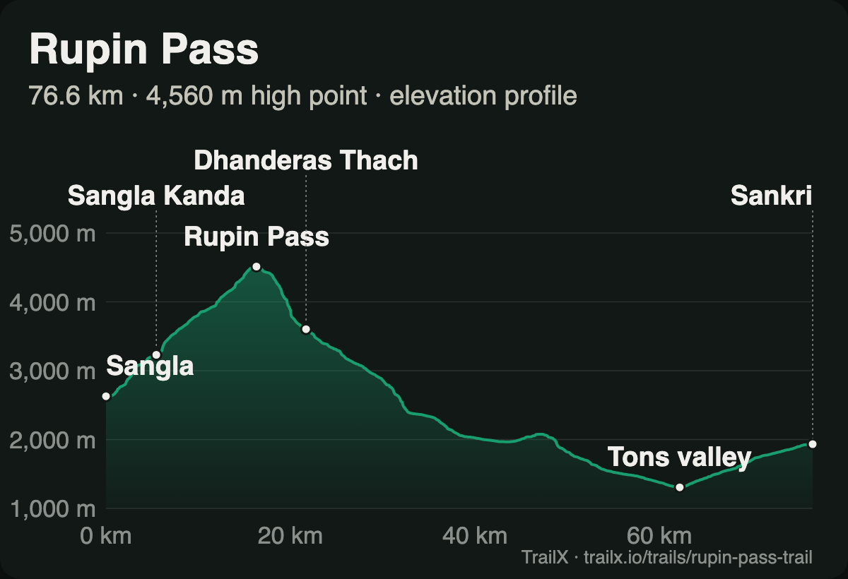 Elevation profile of the Rupin Pass Trail: from about 2,600 m at Sangla up through Sangla Kanda to 4,560 m at Rupin Pass, down past Dhanderas Thach to the Tons valley at about 1,300 m and on to Sankri
What the terrain does. The profile is a single mountain. From Sangla at about 2,600 m, the route climbs nearly 2,000 m in the first 16 km, the steepest sustained climb in this guide, to cross the pass at 4,560 m on our data (around 4,650 m on most maps). The final approach is a gully that usually holds snow into June. Then it falls: down to Dhanderas Thach at about 3,600 m in under 6 km, and on down the valley for another 50 km, losing almost 3,500 m in all.
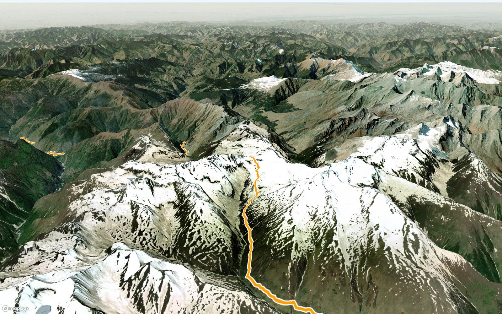 3D view of the Rupin Pass route climbing to the pass through snowfields, the trail in orange on satellite terrain
What waits around the next ridge. From the pass, the Kinner Kailash range behind you and the whole Rupin valley ahead. Below it, the three-tiered Rupin waterfall pouring off a hanging valley, and the meadows of Dhanderas Thach, where many trekkers say the best campsite of their lives is.
- Route: Rupin Pass Trail, 76.6 km, 2,770 m of climbing, rated Extreme
- Season: mid-May to June and mid-September to October
- Access: no special permit, but forest fees and camping charges can apply; most people go with an organised trek
- Why go: more scenery changes in a week than most treks offer in a lifetime
Read how to cross a high pass safely before you go.
5. Kashmir Great Lakes: seven lakes and three passes
If the other four treks have a moment, this one has a day for every moment. The Kashmir Great Lakes trek walks from Sonamarg, the "meadow of gold", to Naranag, crossing three passes above 4,000 m. In between, it passes a chain of alpine lakes, each a different colour, each in its own bowl of meadows and rock: Vishansar, Kishansar, Gadsar, the Satsar lakes, and finally the twin lakes of Gangabal and Nundkol under Mount Harmukh.
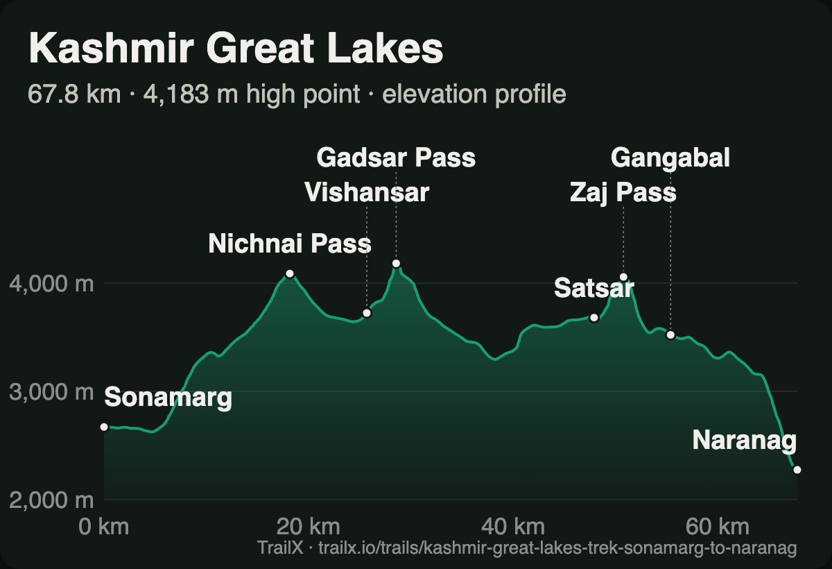 Elevation profile of the Kashmir Great Lakes Trek: from about 2,700 m at Sonamarg over Nichnai Pass, Vishansar and Gadsar Pass at 4,183 m, then Satsar, Zaj Pass and Gangabal before descending to Naranag at about 2,270 m
What the terrain does. Three humps tell the story. The first is the long climb out of Sonamarg, through birch forest and the Nichnai valley, to Nichnai Pass at about 4,090 m. Then comes a drop to the meadows of Vishansar, and a short, steep pull past Kishansar to Gadsar Pass, the high point at 4,183 m. Next is a long descent past Gadsar Lake to the army camp below it, a climb back up to the Satsar lakes, and the third pass, Zaj, before Gangabal. The last day is the hard one on the knees: about 1,300 m straight down through pine forest to Naranag.
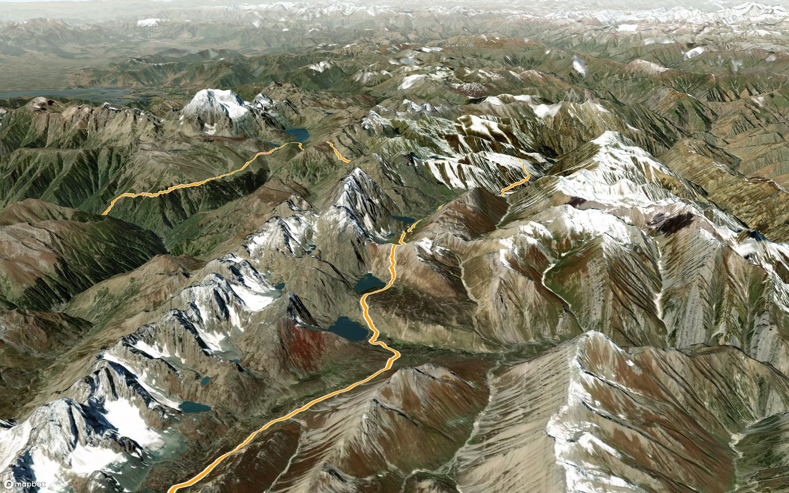 3D view of the Kashmir Great Lakes route from Vishansar past Kishansar to Gadsar Pass, with the lakes strung along the trail, the trail in orange on satellite terrain
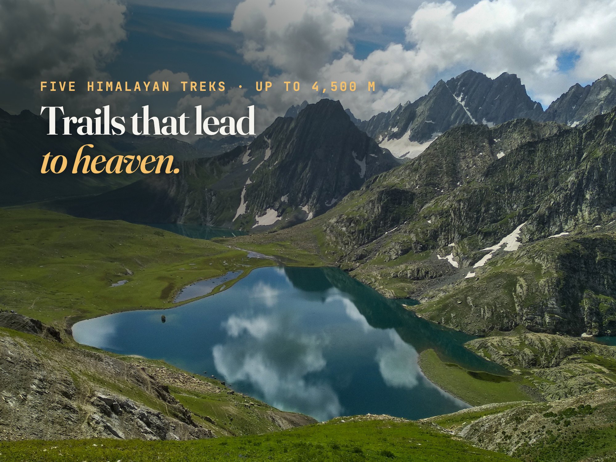
What waits around the next ridge. From Gadsar Pass, the view back over Vishansar and Kishansar, the photograph on the cover of this guide, is one of the great sights of the Indian Himalaya. Shepherds bring their flocks up to these meadows in summer, and you'll share many campsites with them.
- Route: Kashmir Great Lakes Trek: Sonamarg to Naranag, 67.8 km, about 2,960 m of climbing, rated Extreme. New on TrailX.
- Season: July to mid-September; snow can linger on the passes into July
- Access: carry original photo ID for the army checkposts at Gadsar and Satsar, and check the current registration rules for trekkers in Jammu and Kashmir
- Why go: the most beautiful high-altitude lakes most trekkers will ever see
For every lake along the way, see our guide to the great lakes of Kashmir.
Before you go
- Acclimatise. Rupin Pass and the Kashmir Great Lakes both cross 4,000 m. Gain height gradually, drink plenty, and turn back if symptoms of altitude sickness get worse. See our guide to crossing Himalayan passes.
- Pick the right season. The Valley of Flowers is best in the monsoon. Kashmir Great Lakes is only possible in high summer, and Rupin is best before or after it. Har Ki Dun and Kuari Pass work in most seasons. For go or no-go calls, our guide to reading weather charts can help.
- Plan your logistics. On every route except the Valley of Flowers, there are long stretches with no villages, no shops and no phone signal. Carry or hire full camping gear, or go with a licensed trek operator.
- Download before you go. Save the GPX from each trail page, or open the route in the TrailX app for offline navigation.
- Leave it as you found it. Carry out every piece of rubbish, stay on the trail in the meadows, and camp away from lake shores.
See it before you go
There's a moment on every one of these trails when the mountains stop being a distant line and become a place you are standing in. You can't download that. But you can see what's coming.
Open any of these routes in the free TrailX app for iPhone or Android, tap the preview button on the map, and fly the whole trek in 3D: every pass, every lake, every ridge you'll cross, on the real terrain. Here's how the 3D flyover works.
Explore the route in 3D on TrailX before you go. Then go and find the ridge where it all opens up.

Written by
TrailX
Hikers, riders and drivers mapping the world's trails, and sharing what we learn along the way.
Responses