Che Guevara's Motorcycle Diaries Route: The 1952 Journey on Today's Map
In 1952 Ernesto Guevara and Alberto Granado crossed South America on a 1939 Norton. We mapped their route on today's roads: 12,300 km, and how to ride it now.
On this page
On 4 January 1952, two young Argentines rode out of Buenos Aires on a 1939 Norton 500 so loaded with luggage that it could barely turn. Ernesto Guevara was 23 and a few exams short of a medical degree. Alberto Granado was 29, a biochemist who had worked at a leprosy colony in Córdoba province. They called the bike La Poderosa II, "the Mighty One", and they planned to ride it to North America.
It didn't get that far. La Poderosa gave out in southern Chile, seven weeks in. The pair carried on anyway, on trucks, ships, river boats, a raft and a military plane, and reached Caracas seven months after they set out. Guevara's notes from the trip became The Motorcycle Diaries, and the journey is often called the moment Ernesto began to turn into Che.
We wanted to see what their route looks like now. We took the stops and dates from Guevara's diary, routed them over today's roads, and drew the river, sea and air legs where no road runs. Where a stretch had no TrailX route, we made one, so you can open, download and follow the road sections yourself.
Two friends and a 1939 Norton
The plan. The trip was hatched in October 1951 over mate under the vine at Granado's house in Córdoba. In Guevara's account, the question came out of nowhere: why not go to North America? "On La Poderosa, man." Their only rule, he wrote, was improvisation.
The bike. La Poderosa II was Granado's Norton, a single-cylinder 500 cc machine already more than ten years old. Loaded with two riders, a tent, sleeping bags and spares, it crashed often on the gravel roads of Patagonia, and it was in and out of workshops all the way to Chile.
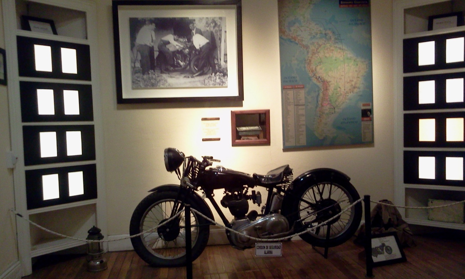 A black 1939 Norton motorcycle on display in a museum, below a framed photograph and a map of South America
A Norton like La Poderosa II at the Museo Casa de Ernesto Che Guevara in Alta Gracia, Córdoba. Photo: Lu Brito, CC BY-SA 4.0, via Wikimedia Commons.
The purpose. Both men had a professional interest in leprosy, and the trip took them to leprosaria in Peru, ending with two weeks at the San Pablo colony on the Amazon. What changed Guevara most, by his own account, were the people he met on the way: a communist miner and his wife in the Atacama, the copper workers at Chuquicamata, the indigenous farmers of the Andes, and the patients at San Pablo.
The book. Guevara wrote up his notes after he got home. They were published only in 1993, long after his death, as Notas de viaje, and in English as The Motorcycle Diaries. Walter Salles's 2004 film, with Gael García Bernal as Ernesto, made the route famous again.
The route on today's map
How to read the map. The red line is the part of the journey they rode on La Poderosa II. The amber line is where they went on by truck, bus and lifts, traced over today's roads between the places Guevara named, in order. Blue dashes are boats, ships and the raft; the grey dashes are the train to Machu Picchu; the purple dashes are the flight from Leticia to Bogotá. The water and air lines are schematic. Tap any section for its dates, what happened there in 1952, and what the road is like now. Green lines are TrailX routes you can open, download and follow.
Today's roads between their stops come to 8,807 km, 2,761 km of it on the motorcycle. Add the lakes, the coast, the rivers and the flight, and the whole journey from Buenos Aires to Caracas comes to about 12,300 km. You'll see it given as 8,000 km or 8,000 miles; the gap is mostly what you count. Ours is a modern measurement over today's roads, not a reconstruction of the 1952 tracks.
The journey at a glance
| Section | Dates in 1952 | How they travelled | Distance today | Can you do it now? |
|---|---|---|---|---|
| Buenos Aires to Bariloche | 4 January – 11 February | La Poderosa II | ≈2,199 km | Yes, paved all the way |
| Across the Andes by lake | 12–14 February | Lake steamers, bike on board | n/a | On foot as a passenger (Cruce Andino); vehicles use the Cardenal Samoré pass |
| Petrohué to Los Ángeles | 14–27 February | La Poderosa II, until it died | ≈562 km | Yes |
| Los Ángeles to Valparaíso | 27 February – 7 March | Truck, then lifts | ≈630 km | Yes |
| Valparaíso to Antofagasta | 8–10 March | Stowaways on a cargo ship | n/a | By road only (Ruta 5) |
| Atacama to Tacna | 11–24 March | Lifts and trucks | ≈971 km | Yes |
| Tacna to Cusco and Machu Picchu | 24 March – 7 April | Trucks, then train | ≈802 km | Yes; Machu Picchu by train or on foot |
| Cusco to Lima | 7 April – 1 May | Trucks | ≈1,325 km | Yes, with landslides in the rains |
| Lima to Pucallpa | 17–24 May | Truck | ≈793 km | Yes |
| Pucallpa to Leticia | 25 May – 23 June | Riverboats and a raft | n/a | By river only: no road |
| Leticia to Bogotá | 2 July | Military plane | n/a | By air only |
| Bogotá to Caracas | 10–17 July | Bus and truck | ≈1,525 km | Colombia yes, with care; Venezuela: check advice |
Dates are from the itinerary in the Italian edition of Guevara's notes. Distances are for the road legs we routed between their stops.
Section by section
Argentina: the Atlantic coast and Patagonia
Then. From Buenos Aires they rode south to the sea at Villa Gesell, then to Miramar, where Ernesto's girlfriend María del Carmen "Chichina" Ferreyra was spending the summer. The planned two days became eight. Across the pampa to Bahía Blanca, Ernesto came down with a fever of 40 °C and spent several days in the hospital at Choele Choel. On the gravel to Piedra del Águila they crashed again and again. At San Martín de los Andes the park superintendent let them sleep on straw in a tool shed, and they earned their meat helping at a barbecue for a local motor race.
Now. Every road on this stretch is paved. Ruta 2 is a motorway to the coast, and the Patagonian legs are long two-lane roads across the steppe, with strong west winds and few fuel stops between Choele Choel and Piedra del Águila. Ride it between November and March for the warmest weather. If you're coming from Bahía Blanca, the Cerro Tres Picos Hike (29.1 km) climbs the highest point in Buenos Aires province, in the Sierra de la Ventana.
Follow it on TrailX: Buenos Aires to Miramar via Villa Gesell: The Atlantic Coast Road (644.7 km, on-road) and Bahía Blanca to San Martín de los Andes via Choele Choel (923.0 km, on-road), both new for this guide. The trip started in Córdoba, where Granado lived: Córdoba to Sierras Chicas Ride (95.9 km, cycling) rides out into the hills above the city. More in Argentina.
The Seven Lakes Road to Bariloche
Then. From San Martín de los Andes they rode the Seven Lakes Road, a gravel track then, south through the forests to Lake Nahuel Huapi. Guevara named a chapter after it. In Bariloche, sheltering from a storm in the police station while they waited for the lake steamer, he read a letter from Chichina that ended their romance.
Now. Ruta 40 is paved the whole way, and it's one of the best-known drives in Argentina: a day of bends, forest and lake views past Lácar, Machónico, Falkner, Villarino, Escondido, Correntoso and Espejo. Snow can close it in winter.
Follow it on TrailX: Ruta de los Siete Lagos: San Martín de los Andes to Bariloche (190.8 km, on-road), new for this guide, and the Bariloche Refugios Trek (102.7 km, hiking) through the mountain huts above Bariloche.
Across the Andes by boat
Then. There was no road over the Andes here. They crossed by lake: the steamer Modesta Victoria across Nahuel Huapi, overland past Laguna Frías to the border, and then across Lago Todos los Santos to Petrohué on an old boat with the bike lashed on board, paying their passage by working the bilge pump.
Now. The same crossing runs as the Cruce Andino, a full-day tourist trip of boats and buses between Bariloche and Puerto Varas. It doesn't carry vehicles. Riders and drivers cross by the Cardenal Samoré pass (Ruta 231/215), north of Nahuel Huapi, to Osorno.
Chile: the end of La Poderosa
Then. In Temuco the local paper ran a story on "two Argentine leprosy experts" touring Latin America by motorcycle, a reputation they were happy to live up to. After Temuco the Norton fell apart: a puncture in the rain, crashes, a broken frame welded in Lautaro. Near Los Ángeles it gave out for good, and they bunked with the town's volunteer firemen. The bike went north on a truck and was left in Santiago. From then on, Guevara wrote, they were "bums without wheels".
Now. Ruta 5, the Pan-American Highway, is a fast tolled motorway the whole way from Osorno to Santiago. If you want something slower near Temuco, our Red Interlagos Drive to Pucón (236.8 km, on-road) runs through the lakes and volcanoes east of the highway.
Easter Island. In Valparaíso they tried and failed to get a boat to Rapa Nui, where they wanted to visit the leprosarium. You can fly there now from Santiago; our Rano Kau and Orongo Hike from Hanga Roa (8.3 km, hiking) climbs to the crater and the ceremonial village of Orongo. More in Chile.
The Atacama and Chuquicamata
Then. They stowed away on the San Antonio, a cargo ship, were found, and worked their way to Antofagasta. Walking and hitching into the desert, they spent a night with a communist miner and his wife who had nowhere to go, and Guevara wrote about the cold and the couple at length. At Chuquicamata, then owned by American companies, he asked how many men had died building the mine.
Now. A paved highway climbs from the coast past Baquedano and across the Atacama to Calama. There are almost no services on the way, so carry water and fill the tank. Chuquicamata town was closed in 2007 and its people moved to Calama, but the mine still works, and you can book a tour from Calama. North from there, Ruta 5 runs through Iquique to Arica and the Peruvian border at Chacalluta.
Follow it on TrailX: Antofagasta to Calama via Baquedano: Into the Atacama (218.9 km, on-road), new for this guide.
Peru: the Altiplano, Cusco and Machu Picchu
Then. They entered Peru at Tacna on 24 March and rode trucks up to Tarata, which Guevara called the new world, and across the Altiplano to Puno and Lake Titicaca. In Cusco, "the navel of the world", they spent more than a week among the Inca walls, and on 3 April took the train to Machu Picchu. Guevara called the ruins "the pure expression of the most powerful indigenous race in the Americas".
Now. The roads are paved, but most of this section is above 3,500 m, and the climb from Tacna to the Altiplano takes you from near sea level to over 4,000 m in a few hours. Give yourself time to acclimatise, carry warm clothes, and travel in the dry season from May to October. Trains still run to Machu Picchu from Cusco and Ollantaytambo; you can't drive there. The classic way to arrive is on foot.
Follow it on TrailX: Tacna to Puno via Tarata: Over the Altiplano to Lake Titicaca (415.6 km, on-road) and Puno to Cusco via Juliaca and the La Raya Pass (386.3 km, on-road), both new for this guide; then the Inca Trail to Machu Picchu (Classic Route from Km 82) (35.7 km, hiking), and near Cusco the Waqrapukara Fortress Trek (13.8 km, hiking). More in Peru.
From Cusco to Lima
Then. West by truck through Abancay to the leprosarium at Huambo, near Huancarama, then four days in Andahuaylas, Ayacucho, Huancayo and over the Andes to Lima, which they reached on 1 May. In Lima they spent two weeks with Dr Hugo Pesce, Peru's leading leprosy doctor and a Marxist. Guevara later said those evenings of talk were important to him.
Now. The highway through the Apurímac canyon climbs and drops more than 2,000 m several times, and landslides close it in the rainy season from December to March. The Carretera Central from Huancayo to Lima crosses the Andes at more than 4,800 m. Allow two long days from Cusco to Ayacucho alone.
Follow it on TrailX: Cusco to Ayacucho via Abancay and Andahuaylas (551.6 km, on-road), new for this guide.
Into the Amazon
Then. From Lima a truck took them over the mining town of Cerro de Pasco and down to Pucallpa, on the Ucayali. They spent a week on the riverboat La Cenepa to Iquitos, then went on to the San Pablo leper colony, where about 600 patients lived on the far bank of the Amazon from the staff. On 14 June the colony threw a party for Ernesto's 24th birthday, and that night he swam across the river to the patients' side. When they left, the patients built them a raft, the Mambo-Tango, and they drifted downriver towards Colombia.
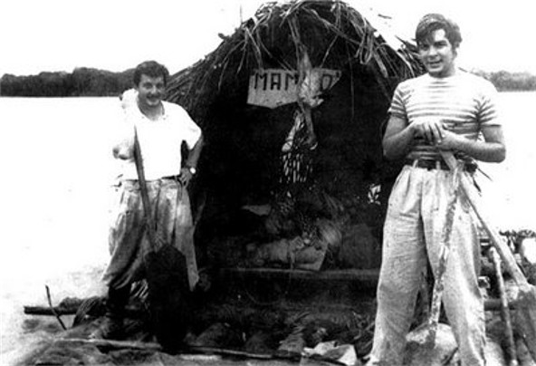 Alberto Granado (left) and Ernesto Guevara on the Mambo-Tango raft on the Amazon, June 1952
Granado (left) and Guevara on the Mambo-Tango, the raft the San Pablo patients built for them, June 1952. Photo: unknown author, public domain, via Wikimedia Commons.
Now. The road ends at Pucallpa. From there to Iquitos and Leticia the only way is by river, on the lanchas that carry cargo and passengers for three to five days to Iquitos, then a fast boat on to Santa Rosa, across the river from Leticia. You can't take a vehicle on with you in any practical way. This is the part of the journey you do as they did.
Follow it on TrailX: Lima to Pucallpa via Cerro de Pasco and Tingo María (776.4 km, on-road), new for this guide.
Colombia and Venezuela
Then. In Leticia they spent nine days, earning their keep by training the local football team, with Ernesto in goal. A Colombian Air Force plane, which Guevara called "a cocktail-shaker", flew them to Bogotá, a city under heavy police repression that he described in a letter to his mother. They left by bus for Cúcuta, crossed into Venezuela, and reached Caracas on 17 July. There the two friends parted. Granado stayed on to work at a leprosarium; Guevara got a seat on a cargo plane to Miami, spent about a month there, and flew home to Buenos Aires to finish his degree.
Now. No road reaches Leticia; you fly in and out. From Bogotá, the road to Cúcuta through Tunja and Bucaramanga is long but good, though several governments advise against travel to parts of Norte de Santander near the border. The UK, US and others advise against all or most travel to Venezuela.
Follow it on TrailX: Bogotá to Cúcuta via Tunja and Bucaramanga (563.6 km, on-road), new for this guide, and near Bogotá the Bogotá Hill Road Ride (27.5 km, cycling) and Vía al Llano Descent from Bogotá (89.0 km, cycling). In the Venezuelan Andes, Pico El Águila Andes Descent (40.4 km, cycling) descends from one of the highest road passes in the country.
Can you ride the Motorcycle Diaries route today?
Most of it, yes, but not end to end on one bike. Three things break the road:
- The Andean lakes. The 1952 crossing is now a passenger-only tourist route. On a motorcycle, cross by the Cardenal Samoré pass instead and rejoin the route at Osorno.
- The Amazon. There is no road from Pucallpa to Iquitos or Leticia. Riders either ship the bike from Pucallpa on a river cargo boat (slow, informal and uninsured) or, more often, end the ride in Peru and do the Amazon as passengers.
- Venezuela. With most governments advising against travel there, the last leg from Cúcuta to Caracas is for experienced travellers who have checked the latest advice.
A realistic 2026 version looks like this: ride from Buenos Aires to Patagonia and the Seven Lakes, cross to Chile at Cardenal Samoré, ride north up Chile and through the Atacama, cross to Peru at Tacna, and take the Altiplano to Cusco and on to Lima. That's about 7,800 km, roughly six to eight weeks at a pace that leaves time to stop. Then fly or take the boats for the Amazon and Colombia.
- Season. The route crosses climates that don't line up. Patagonia is best from November to March, which is the rainy season on the Altiplano and in the Peruvian Andes. If you're riding the whole way, start in Argentina in December or January and reach Peru as the rains end in April, much as Guevara and Granado did.
- Altitude. Several days run above 4,000 m. Plan slow days at Puno and Cusco before the high passes.
- Paperwork. A rented or foreign motorcycle needs a temporary import permit at each border, plus local third-party insurance (Peru's is called SOAT). Carry the original registration, an International Driving Permit and copies of everything.
- Fuel. Long stretches in Patagonia and the Atacama have no fuel for 200 km or more. Fill up whenever you can.
Our first overlanding trip checklist covers the vehicle and paperwork, and the multi-stop road trip planner shows how to break a long route like this into daily legs.
Why the journey still matters
Guevara and Granado were not explorers. They took roads and rivers that people in the Andes and the Amazon used every day, and they had almost no money. What made the trip remarkable was what they saw on it, and what it did to one of them. You can still follow most of it, by road, rail and river, and see the same landscapes, though the roads are paved now and the copper mine is in Chilean hands.
For another long road with a story, see how we traced the old Kolkata to London bus route, and Phileas Fogg's world tour in 80 days.
Written by
fakir27
TrailX scout with more than 90 mapped routes, from the Trans Uttarakhand Shiva Trail to the roads to Kailash and Lipulekh.
Responses