On this page
- 01Where exactly is the S-bend?
- 02The S-bend in numbers
- 03Why turning circle isn't the real problem
- 04What the Alto video does and doesn't prove
- 05The rest of the Adi Kailash road
- 06How the S-bend compares with India's toughest roads
- 07Which vehicle for which road?
- 08Before you drive the Adi Kailash road
- 09How we measured
- 10Sources
- 11Where to next?
This summer a short clip of a Maruti Suzuki Alto negotiating a tight zig-zag on the road to Adi Kailash went viral, and with it a stretch of road that locals simply call the "S-bend". It looks terrifying on a phone screen: a small hatchback, a stack of hairpins, a loose grey hillside and nothing much between the road and the drop.
Videos make roads look steeper, narrower and scarier than they are, and sometimes less dangerous than they are. So we did what a video can't: we found the S-bend on the map, measured its geometry and gradient from OpenStreetMap and elevation data, checked how real vehicles fit through it, and then ran the same analysis on six of India's most talked-about mountain roads.
Where exactly is the S-bend?
The S-bend is on the Tawaghat–Gunji border road in Pithoragarh district, Uttarakhand, the road that carries pilgrims and traders up the Kali river gorge towards Gunji, Adi Kailash and Om Parvat. Local news reports place it between Lamari and Budhi, and list it alongside Malghat and Gasku as one of the road's recurring landslide spots.
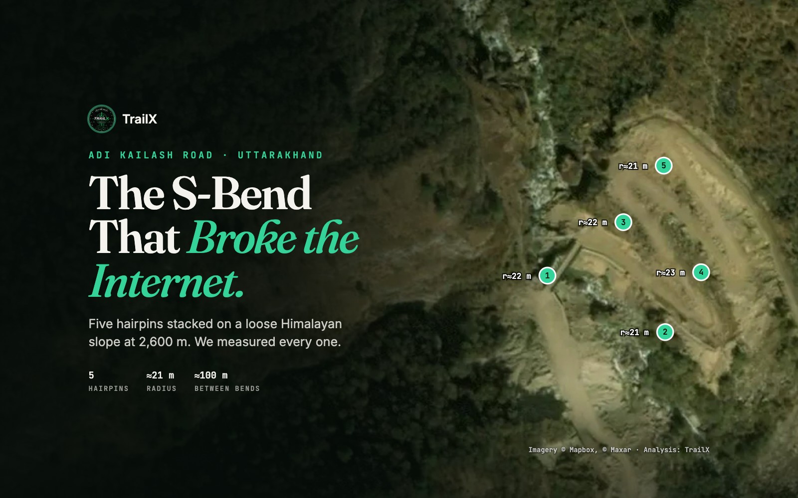
No source publishes its exact position, so we looked for it in the map data. Between Lamari and Budhi there is exactly one place where the road folds back on itself in a run of alternating hairpins: about 55 km from Dharchula, just before Budhi, at roughly 30.104° N, 80.818° E and about 2,550–2,630 m above sea level. Satellite imagery shows the road zig-zagging up a bare debris fan beside a stream, which matches the descriptions of loose rock and recurring slides. We're confident this is the S-bend, but it's our identification, not an official one.
The S-bend in numbers
Here's what the road geometry and elevation data say about the S-bend itself.
| Measure | S-bend (estimate) | IRC:52 hill-road norm |
|---|---|---|
| Location | Tawaghat–Gunji road, between Lamari and Budhi (≈30.104° N, 80.818° E) | — |
| Altitude | ≈2,552–2,628 m | — |
| Hairpins | 5, alternating, in about 400 m of road | — |
| Turn at each hairpin | 154–164° | — |
| Centreline radius | ≈21–23 m | Inner edge at least 14 m |
| Distance between hairpins | ≈100 m | At least 60 m |
| Average gradient across the stack | ≈8% (2,552 to 2,628 m over 1 km) | At most 2.5% within a hairpin |
| Surface | Mapped as paved; loose debris, mud and edge collapses reported in 2026 | Full width surfaced |
A few things stand out.
- It's a stack, not a single S. The road makes five alternating hairpins in about 400 m of road, each one roughly 100 m from the next. That's what gives the zig-zag its dramatic look from above.
- The bends are tight but not unusually tight. The centreline radius of each hairpin is about 21–23 m. India's hill road code, IRC:52, asks for an inner-edge radius of at least 14 m at a hairpin and at least 60 m between successive hairpins, and on both counts the S-bend appears to comply.
- The slope is the hard part. Across the whole stack the road gains about 76 m in a kilometre, an average of roughly 7–8%. IRC:52 limits the gradient within a hairpin itself to 2.5%. At this resolution we can't tell how flat each individual bend is, but the road between them is clearly steep, so a driver is changing direction and climbing at the same time.
- The ground is loose. The road is mapped as paved, but in 2026 it was buried in mud (August) and lost about 10 m of its edge in a collapse (September). On the imagery it crosses a bare debris fan with no visible barriers.
Why turning circle isn't the real problem
The most common claim in the comments under the viral video is that the Alto made it because it has a small turning circle. The numbers say otherwise. Here's how much space popular vehicles need through a bend like this, using manufacturers' specifications and the standard low-speed off-tracking formula (the rear wheels cut inside the front wheels by roughly R − √(R² − L²), where R is the radius and L the wheelbase).
| Vehicle | Wheelbase | Width | Min. turning radius | Rear-wheel cut-in at r≈21 m | Road width swept |
|---|---|---|---|---|---|
| Maruti Suzuki Alto K10 | 2.38 m | 1.49 m | 4.5 m | 0.14 m | ≈1.6 m |
| Maruti Suzuki Swift | 2.45 m | 1.74 m | 4.8 m | 0.14 m | ≈1.9 m |
| Mahindra Thar (3-door) | 2.45 m | 1.82 m | ≈5.5 m | 0.14 m | ≈2.0 m |
| Maruti Suzuki Jimny (5-door) | 2.59 m | 1.65 m | 5.7 m | 0.16 m | ≈1.8 m |
| Toyota Fortuner | 2.75 m | 1.85 m | 5.8 m | 0.18 m | ≈2.0 m |
| Toyota Innova Crysta | 2.75 m | 1.83 m | 5.4 m | 0.18 m | ≈2.0 m |
| Mahindra Scorpio-N | 2.75 m | 1.92 m | ≈5.4 m | 0.18 m | ≈2.1 m |
| Force Traveller 3700 (17-seat) | 3.70 m | 1.90 m | ≈6.5 m | 0.33 m | ≈2.2 m |
| Tata LP 712 hill bus (32-seat) | 4.20 m | 2.20 m | ≈7.3 m | 0.42 m | ≈2.6 m |
Every vehicle on the list, from an Alto to a 32-seat bus, turns far tighter than the S-bend's hairpins. Nobody needs a three-point turn here if the road is clear. And the difference in the width of road each vehicle sweeps is small: about 1.6 m for an Alto against about 2.6 m for a hill bus.
What actually makes the S-bend demanding is the combination:
- Climbing while turning. At 7–8% the driver has to keep the engine in its torque band, steer through a hairpin and avoid stalling, all at walking pace. Stop mid-bend and restarting uphill on loose stones is the hardest moment of the whole manoeuvre.
- Traction. Loose rock and mud reduce the grip available for both steering and climbing. Ask the front tyres for too much of either and they push wide, which on a hairpin means towards the outside edge.
- The outside edge. A tight bend with a wide, firm shoulder forgives a mistake. A bend on a debris slope with no barrier doesn't. This is where consequence matters more than difficulty.
- Traffic. In 2026 the route carried 61,950 visitors, more than double the year before, and on 5 October it saw its first-ever traffic jam at about 14,500 ft. Meeting a bus or a truck in the middle of a stack of hairpins is a very different problem from driving it alone.
What the Alto video does and doesn't prove
The viral clip shows that a light, narrow, short car with a careful driver can get through the S-bend in dry conditions. That's genuinely useful: lightness, a narrow body and short overhangs are real advantages on a narrow, loose hairpin, and a front-wheel-drive car with its weight over the driven wheels can climb surprisingly well.
It doesn't prove that every small car can do the whole route. The S-bend is one short stretch of a road that climbs from about 900 m at Dharchula to about 4,400 m at Jolingkong, through landslide zones, stream crossings, the Budhi–Chiyalekh switchbacks and, late in the season, snow. Nor does it prove that the same climb is safe in rain, in traffic or after a slide.
The rest of the Adi Kailash road
The S-bend isn't even the most demanding stretch of its own road. Between Dharchula and Gunji we count 53 hairpins. The densest 10 km, from the S-bend up through the switchbacks between Budhi and the Chiyalekh meadows, has 34 hairpins, and the Budhi–Chiyalekh climb averages about 8%. Our exposure index (explained below) puts about 18% of the road alongside ground that falls away at 45° or more, much of it where the road is cut into the walls of the Kali gorge.
2026 showed how quickly conditions change:
- 11 August: mud and debris closed the road at the S-bend for about 12 hours.
- 5–8 September: a section near the S-bend was washed out, with repeated slides at Malghat and Gasku.
- 11 September: the Kulagad Bailey bridge, rebuilt only two weeks earlier, was washed away by a flash flood, and the second phase of the yatra was postponed to 20 September.
- 27–28 September: about 10 m of road at the S-bend collapsed in heavy rain, stranding around 550 people until the Border Roads Organisation reopened it the next afternoon.
- 5 October: snow banks and record numbers of vehicles caused the first traffic jam at Adi Kailash, at about 14,500 ft.
You can drive the whole road on TrailX: our Adi Kailash Road route runs from Dharchula past the S-bend and Gunji to Jolingkong.
How the S-bend compares with India's toughest roads
To compare roads fairly, we ran the same analysis on each one: hairpins and their radii from the OpenStreetMap road geometry, altitude and gradient from SRTM elevation data, and an exposure index: the share of the road where the ground beside it drops away at 45° or more within 60 m, a rough measure of how often there's a big drop at the edge.
| Road | High point (≈ m) | Hairpins | Densest 10 km | Tightest hairpin (r) | Main climb (average) | Exposure index | TrailX route |
|---|---|---|---|---|---|---|---|
| Adi Kailash road (S-bend) | 3,296 | 53 | 34 | ≈17 m | 2.9% over 80 km (7–8% around the S-bend) | 18% | Drive it |
| Sach Pass | 4,397 | 65 | 15 | ≈17 m | 6.4% over 46 km | 11% | Drive it |
| Killar–Kishtwar road | 2,674 | 23 | 8 | ≈17 m | Mostly downhill along the gorge | 30% | Drive it |
| Shinku La | 5,039 | 25 | 9 | ≈19 m | 4.2% over 41 km | 1% | Drive it |
| Zoji La | 3,538 | 9 | 4 | ≈20 m | 4.0% over 22 km | 3% | Drive it |
| Khardung La | 5,349 | 24 | 7 | ≈21 m | 5.0% over 37 km | 0% | Drive it |
| Umling La | 5,792 | 29 | 16 | ≈20 m | 4.9% over 24 km | 0% | Drive it |
The table shows that "difficult" means different things on different roads.
Sach Pass: the long, rough climb
Sach Pass (about 4,414 m) between Chamba and the Pangi valley has the steepest sustained climb of any road here: about 6.4% for 46 km from the valley floor to the top, largely unpaved, with snow walls and glacier crossings early in the season. It also has more hairpins than the Adi Kailash road, but spread over a much longer climb. The Chamba–Killar bus only resumed on 1 July 2026 after monsoon damage the year before.
The Killar–Kishtwar "cliffhanger": exposure over everything
The Killar–Kishtwar Cliffhanger Road has few hairpins and little climbing, but it has by far the highest exposure index in our sample: nearly 30% of the road runs beside ground falling away at 45° or more. It's carved into the walls of the Chenab gorge, mostly single-lane and unpaved, with long sections where one vehicle has to reverse to let another pass. It's so steep-sided that 30 m elevation data can't place the road reliably, which is why we don't give it a gradient.
Shinku La, Khardung La and Umling La: altitude over technique
These three are well-built, mostly paved roads with gentle average gradients of 4–5%. Their difficulty is the height. Shinku La tops out at about 5,040 m, Khardung La at about 5,359 m and Umling La at about 5,799 m, where the air holds roughly half the oxygen it does at sea level. All of the Umling La road is above 4,000 m. Altitude slows reactions and judgement long before the road gets technical. (Umling La was the world's highest motorable road until October 2025, when Mig La, also in Ladakh, took the record at about 5,913 m.)
Zoji La: traffic, weather and avalanches
Zoji La is the lowest pass here at about 3,528 m, and on paper the easiest. But it's a narrow shelf road carrying the Srinagar–Leh highway's trucks and army convoys, it's closed by snow for months every winter, and in March 2026 an avalanche between Zero Point and Minamarg killed seven people. The Zojila tunnel broke through in June 2026 and is due to open in early 2028.
So where does the S-bend fit?
The S-bend is a short, concentrated manoeuvring challenge: the densest hairpins of any road we measured, on loose ground, at a moderate altitude. Sach Pass is harder over a whole day, the Killar–Kishtwar road is far more exposed, and the Ladakh passes are a test of the body as much as the vehicle. None of these roads is "the hardest"; each one is hard in a different way.
Which vehicle for which road?
| What matters | Adi Kailash S-bend | Sach Pass and the Killar–Kishtwar road | Ladakh high passes |
|---|---|---|---|
| Short wheelbase and narrow body | Helpful, but not decisive | Very helpful where passing space is tight | Minor |
| Low-range gearing or a strong low-speed engine | Very helpful for restarting uphill on loose ground | Very helpful | Helpful; engines lose power at altitude |
| Four-wheel drive | Not essential in dry conditions | Helpful on unpaved, wet or snowy sections | Rarely needed on the paved roads |
| Ground clearance | Moderate is enough on the bend itself | Important on rocky, unpaved stretches | Moderate is enough |
| Good tyres | Essential | Essential | Essential, including in cold |
| Driver experience | Essential | Essential, including reversing on narrow ledges | Essential, plus altitude awareness |
Before you drive the Adi Kailash road
- Permits. Everyone, including Indian citizens, needs an Inner Line Permit, issued offline by the SDM office in Dharchula with a medical certificate and police verification. Permits are suspended when the road is shut.
- Season. Roughly May to mid-October, with permits often suspended in July and August for the monsoon. The road can close for hours or days after rain anywhere in the season.
- Check the road the day before, and again in the morning. Ask taxi operators in Dharchula: they know which stretches are open.
- Don't stop in the hairpins to film, and don't wave others through a blind bend. Climb the S-bend in one smooth, steady pass in first or second gear.
- Give way uphill traffic room, and if you meet a larger vehicle, stop where the road is widest rather than in a bend.
- Hire a local driver if you don't have Himalayan driving experience. Many visitors use the local taxi union's vehicles and drivers.
The most important skill on a road like this is knowing when not to go.
How we measured
- Road geometry comes from OpenStreetMap, routed with BRouter, which returns the road at full map resolution. We re-sampled it every 5 m and detected hairpins as turns of 150° or more within 60 m of road. Radii are for the centreline.
- Elevation comes from SRTM 30 m data via AWS Terrain Tiles, median-filtered over about 300 m. Gradients are sustained averages, not the steepest few metres. Roads cut into near-vertical cliffs, such as the Killar–Kishtwar road and the descent from Sach Pass to Killar, are beyond what 30 m data can resolve.
- The exposure index samples the terrain 30 m and 60 m either side of the road every 25 m and counts the places where it falls away at 45° or more. It's a proxy, and 30 m data softens real cliffs, so true exposure is higher everywhere.
- Vehicle figures are manufacturer specifications where available. Off-tracking uses the single-unit approximation R − √(R² − L²).
- What we didn't measure: the actual road width, crossfall and surface at the S-bend, which need a survey on the ground. Treat every figure here as a good estimate, not an engineering survey.
Sources
- Amar Ujala (Pithoragarh) and ETV Bharat reporting on the S-bend, Malghat and Gasku landslides, the Kulagad Bailey bridge and the October 2026 traffic jam; The Tribune and The Northern Gazette on the September 2026 postponement of the yatra.
- Pithoragarh district administration for the Adi Kailash route and permits.
- IRC:52-2019, Recommendations about the alignment survey and geometric design of hill roads (Indian Roads Congress), cl. 6.10 on hairpin bends.
- Manufacturer specifications from Maruti Suzuki, Mahindra and Toyota India; Force Motors and Tata specifications via TrucksBuses.
- Wikipedia articles for Sach Pass, Shinku La, Zoji La, Khardung La and Umling La; BRO announcements on Mig La; The Tribune on the Killar–Kishtwar road and the Chamba–Killar bus.
- OpenStreetMap, BRouter and AWS Terrain Tiles for road geometry and elevation; satellite imagery © Mapbox and Maxar.
Where to next?

Written by
TrailX
Hikers, riders and drivers mapping the world's trails, and sharing what we learn along the way.
Responses