On this page
- 01Where is the Kolli Hills ghat road?
- 02The ghat road in numbers
- 03Ten-bend blocks: where the climb gets harder
- 04The tightest bends
- 05What it means for your vehicle
- 06How Kolli compares with South India's other hairpin roads
- 07Before you drive the Kolli Hills ghat road
- 08How we measured
- 09Sources
- 10Where to next?
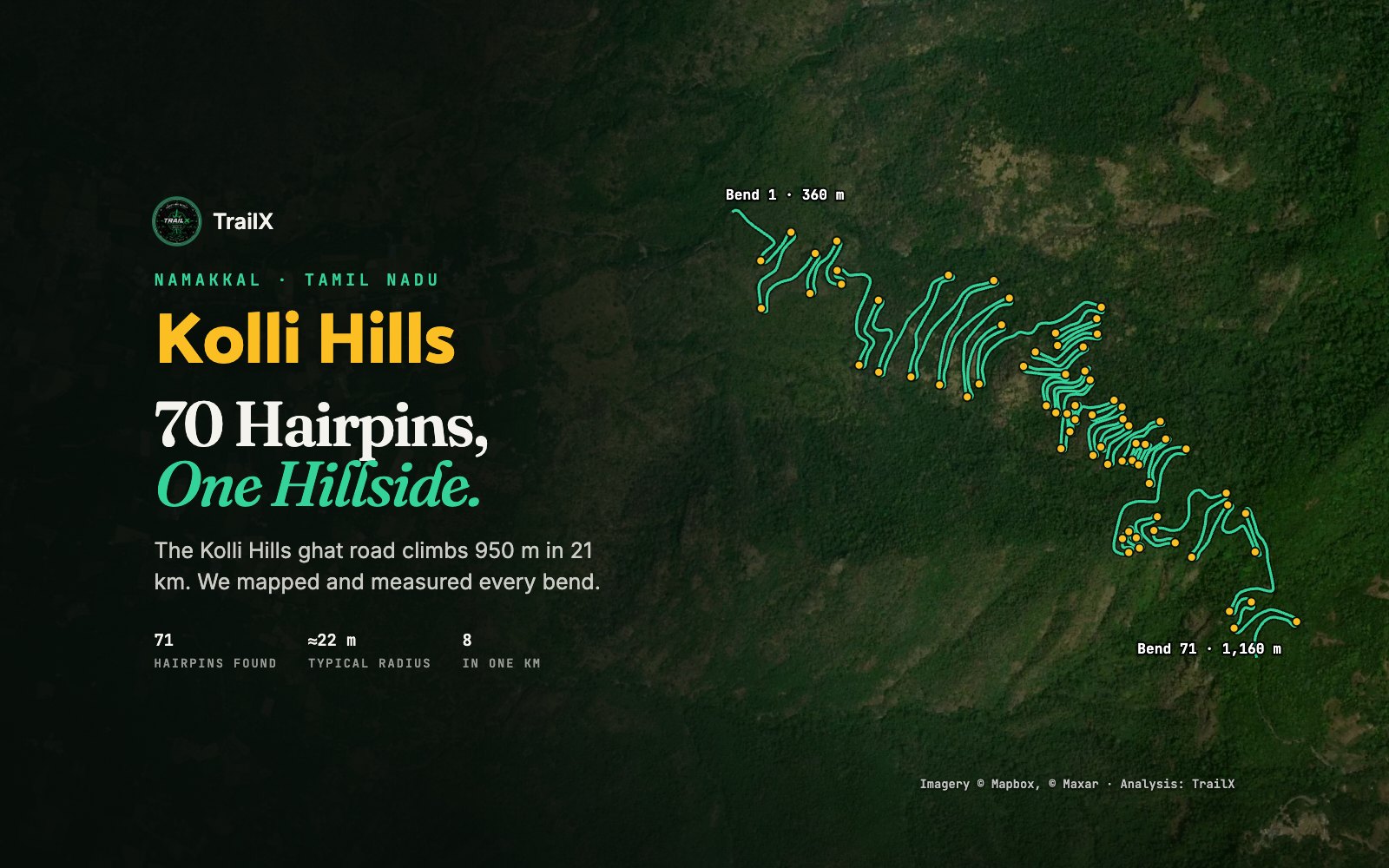
Every list of India's most spectacular roads includes it: the ghat road up to Kolli Hills in Namakkal district, Tamil Nadu, with its famous 70 hairpin bends. In January 2022 Anand Mahindra shared an aerial photo of the bends stacked up the hillside, and it has been a fixture of road-trip feeds ever since.
Tamil Nadu Tourism calls it the road with the most hairpin bends in South India. But how tight are those bends really, how close together, and how steep is the climb between them? We did what a photo can't: we traced the road from OpenStreetMap, ran it against elevation data, measured every bend, and then ran the same analysis on four of South India's other famous ghat roads.
Where is the Kolli Hills ghat road?
The road climbs from Karavalli, at the foot of the hills on the Sendamangalam side, to the Kolli plateau near Solakkadu, and continues to Semmedu, the main village on top. Namakkal is about 45 km away by road, and buses run up from Namakkal and Salem. The bends are numbered from the bottom, from 1 near Karavalli to 70 near the top.
The ghat road in numbers
| Measure | Kolli Hills ghat road | IRC:52 hill-road norm |
|---|---|---|
| Section measured | Karavalli to the top of the ghat, 21.3 km | — |
| Altitude | ≈252 m at Karavalli to ≈1,200 m on the plateau | — |
| Total climb | ≈950 m | — |
| Hairpins (turns of 150° or more) | 71 by our count; 70 signposted | — |
| Where the hairpins are | Between km 1.9 and km 20.0 (an 18 km stretch) | — |
| Centreline radius | ≈19–30 m, median ≈22 m | Inner edge at least 14 m |
| Distance between hairpins | Median ≈235 m, shortest ≈75 m | At least 60 m |
| Densest kilometre | 8 hairpins (bends 55–62, ≈1,000–1,060 m) | — |
| Average gradient across the hairpins | ≈4.5% | At most 2.5% within a hairpin |
| Steepest kilometre | ≈7.7% (bends 33–39, km 12–13) | — |
A few things stand out.
- The "70" is real. Counting every turn of 150° or more, we find 71 hairpins, which matches the 70 on the signboards to within one. (One of our "hairpins" may be two signposted bends merged, or a bend the signboards don't count, so our numbering below may drift by one from the boards.)
- It's relentless rather than steep. The road gains about 820 m across its hairpins at an average of just 4.5%, and even the steepest kilometre is under 8%. Kolli isn't a steep road. What makes it tiring is that you turn hard roughly every 235 m for 18 km.
- The middle third is the busiest. The bends get closer together as you climb: 11 hairpins in the first 5 km, 13 in the next 5, then 25 between km 10 and 15 and 22 between km 15 and 20. The densest kilometre, from bend 55 to bend 62 at about 1,000 m, packs in 8 hairpins.
- The bends are built to the book. IRC:52, India's hill-road code, asks for an inner-edge radius of at least 14 m at a hairpin and at least 60 m between successive hairpins. Kolli's tightest centreline radius is about 19 m and its shortest gap about 75 m, so on our measurements every bend complies.
Ten-bend blocks: where the climb gets harder
| Bends | Length | Altitude | Climb | Average gradient |
|---|---|---|---|---|
| 1–10 | 2.4 km | ≈355 → 460 m | 105 m | 4.4% |
| 11–20 | 4.2 km | ≈476 → 655 m | 179 m | 4.2% |
| 21–30 | 2.1 km | ≈662 → 750 m | 88 m | 4.2% |
| 31–40 | 1.6 km | ≈752 → 856 m | 104 m | 6.6% |
| 41–50 | 1.6 km | ≈855 → 940 m | 85 m | 5.2% |
| 51–60 | 1.8 km | ≈948 → 1,036 m | 88 m | 4.8% |
| 61–70 | 2.5 km | ≈1,051 → 1,160 m | 109 m | 4.4% |
Bends 31–40 are the crux: ten hairpins in 1.6 km, climbing at 6.6% between them. If your car (or your legs, on a bicycle) is going to complain, this is where it will happen.
The tightest bends
These are the five tightest hairpins by centreline radius. The inside edge is a few metres tighter.
| Our bend no. | Altitude | Turn | Centreline radius |
|---|---|---|---|
| 56 | ≈1,008 m | 262° (almost a loop) | ≈18.6 m |
| 59 | ≈1,027 m | 201° | ≈18.6 m |
| 8 | ≈421 m | 214° | ≈18.7 m |
| 43 | ≈882 m | 210° | ≈19.1 m |
| 16 | ≈578 m | 208° | ≈19.3 m |
Two of the five, bends 56 and 59, are in the densest kilometre. Bend 56 turns through about 262°, more than a U-turn: the road almost doubles back over itself before setting off again.
What it means for your vehicle
Every vehicle that uses the road, cars to the state-transport buses that serve the plateau, turns comfortably inside a 19 m radius. The rear wheels cut inside the front ones by about 0.15 m for a hatchback, 0.2 m for a large SUV and about 0.8 m for a full-size bus (the single-unit off-tracking formula R − √(R² − L²), where L is the wheelbase). So the bends themselves rarely need a second attempt. The real challenges are elsewhere.
Brakes on the way down
Coming down, the road drops about 950 m. That height is energy your vehicle has to get rid of, and if you ride the brakes, they get it all.
| Vehicle (loaded) | Energy to shed over the descent | Enough to bring this much water to the boil |
|---|---|---|
| Hatchback, ≈1.1 t | ≈10 MJ | ≈31 litres |
| Seven-seat SUV, ≈2.4 t | ≈22 MJ | ≈67 litres |
| Bus, ≈14 t | ≈130 MJ | ≈390 litres |
Some of that goes into air drag and engine friction, but a driver who coasts down on the brakes is asking small discs and drums to absorb a large share of it all the way down. Hot brakes fade, and brake fade on a hairpin is how descents go wrong. Use a low gear (second or third in most cars) so the engine does the braking, and stop at a wide spot to let the brakes cool if you smell them.
Meeting traffic in a bend
Kolli is a two-way road and buses, vans and trucks use it. Most of the hairpins are blind: you can't see what's coming round the inside. Keep left through every bend, don't cut the inside, and if you meet a bus in a hairpin, stop and let it swing wide. A sounded horn before blind bends is normal practice on Tamil Nadu ghat roads.
Climbing in the heat
On the way up, 18 km of slow, constant turning in first and second gear works the engine and clutch hard, often in heat. Watch the temperature gauge, especially in a loaded car with the air conditioning on, and pull over where it's wide if it starts to climb.
How Kolli compares with South India's other hairpin roads
We ran the same analysis on four other famous ghat roads: hairpins and radii from the OpenStreetMap road geometry, and altitude from elevation data.
| Road | Hairpins (signposted) | Hairpins we detect | Altitude range (≈ m) | Densest kilometre | Median gap between hairpins | Tightest radius |
|---|---|---|---|---|---|---|
| Kolli Hills (Karavalli) | 70 | 71 | 252 → 1,202 | 8 | ≈235 m | ≈19 m |
| Aliyar–Valparai | 40 | 40 | 290 → 1,472 | 5 | ≈380 m | ≈15 m |
| Dhimbam (NH 948) | 27 | 28 | 354 → 1,136 | 6 | ≈260 m | ≈18 m |
| Yercaud | 20 | 20 | 314 → 1,418 | 4 | ≈340 m | ≈19 m |
| Thamarassery churam | 9 | 9 | 48 → 811 | 3 | ≈840 m | ≈15 m |
Our counts match the signposted numbers on all five roads to within one, which gives us confidence in the method. And the comparison shows what makes Kolli different: it isn't the highest or the steepest climb, but no other road here comes close to its density. Kolli packs 8 hairpins into its busiest kilometre, and its typical gap between bends is the shortest of any road we measured.
Aliyar–Valparai: fewer bends, tighter ones
The road from Aliyar up to Valparai has 40 numbered hairpins and climbs higher than Kolli, but they're spread further apart. Its tightest bends (about 15 m) are tighter than any on Kolli. On 17 April 2026 a tourist van went off the road at the 13th hairpin and nine people died; the transport authorities blamed the driver's inexperience on the ghat, and reports also pointed to the low parapet wall.
Dhimbam: the night-ban ghat
The Dhimbam ghat on NH 948, between Sathyamangalam and the Karnataka border, climbs through the Sathyamangalam Tiger Reserve. Since February 2022, on Madras High Court directions, commercial vehicles have been banned at night (6 pm–6 am) and private vehicles from 9 pm to 6 am. Check the current timings before you set out.
Yercaud: the gentle one
Yercaud's 20 hairpins climb more than 1,000 m from Salem, at a similar average gradient to Kolli, but with less than half as many bends. Of the five, it's the gentlest drive.
Thamarassery churam: few bends, big traffic
The Thamarassery pass into Wayanad has only nine hairpins, but it's a main road carrying heavy traffic between Kozhikode and Wayanad. Landslips near the ninth bend closed it in August 2025, and since June 2026 multi-axle heavy vehicles have been banned between 6 am and 8 pm.
And Kalhatty?
The Kalhatty ghat between Masinagudi and Ooty, with its 36 hairpins, is notoriously steep, and access for tourist vehicles has been restricted since 2018. We didn't include it in the table because we couldn't get a clean enough road line for a fair measurement. If you're planning it, check the Nilgiris district's current rules first: they changed again in 2026.
Before you drive the Kolli Hills ghat road
- Go by day. The road is unlit and the bends are blind. Aim to be up or down before dark.
- Descend in a low gear. Use engine braking all the way down and keep your brakes for slowing into bends, not for holding your speed.
- Keep left in every bend, sound your horn before blind ones, and let buses and trucks take the wide line.
- Don't stop in a hairpin to take photos. There are wider spots between bends; use those.
- Watch for festival traffic. For the Valvil Ori festival on 2–3 August 2026, the district made the roads one-way: up via the Karavalli ghat and down via the Mullukurichi ghat. Expect similar arrangements on festival days and long weekends.
- Avoid the monsoon if you can. Heavy rain brings landslips and poor visibility to every ghat road in the region.
- On top, the main sights are the Agaya Gangai waterfall (a steep walk of about a thousand steps each way), the Arapaleeswarar temple, and viewpoints such as Seekuparai.
You can drive the whole climb on TrailX: our Kolli Hills Ghat Road route runs from Karavalli up all 70 bends to the plateau, with the elevation profile and a GPX download for offline navigation.
How we measured
- Road geometry comes from OpenStreetMap, routed with BRouter at full map resolution. We re-sampled it every 5 m and detected hairpins as turns of 150° or more within 60 m of road. Radii are for the centreline.
- Elevation comes from SRTM 30 m data via AWS Terrain Tiles, median-filtered over about 300 m. Gradients are sustained averages, not the steepest few metres.
- Vehicle figures use the single-unit off-tracking approximation R − √(R² − L²) and typical wheelbases. Brake energy is m × g × h for a 950 m descent; in practice drag, rolling resistance and engine braking take some of it.
- What we didn't measure: the actual road width, crossfall and surface, which need a survey on the ground. Treat every figure here as a good estimate, not an engineering survey.
Sources
- Namakkal district administration on Kolli Hills, its sights and the Valvil Ori festival; Tamil Nadu Tourism on the 70 hairpin bends.
- DT Next on the August 2026 one-way traffic arrangements.
- Curly Tales (January 2022) on Anand Mahindra's post of the Kolli Hills bends.
- IRC:52-2019, Recommendations about the alignment survey and geometric design of hill roads (Indian Roads Congress), cl. 6.10 on hairpin bends.
- The Statesman on the April 2026 Valparai accident; LiveLaw on the Dhimbam night ban; Onmanorama and The New Indian Express on the Thamarassery pass; Nilgiris district administration on the Kalhatty road.
- OpenStreetMap, BRouter and AWS Terrain Tiles for road geometry and elevation; satellite imagery © Mapbox and Maxar.
Where to next?

Written by
TrailX
Hikers, riders and drivers mapping the world's trails, and sharing what we learn along the way.
Responses